
Baubau topographic map
Interactive map
Click on the map to display elevation.
About this map
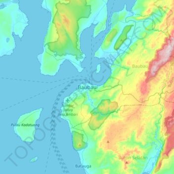
Name: Baubau topographic map, elevation, terrain.
Location: Baubau, Southeast Sulawesi, 97326, Indonesia (-5.62203 122.44577 -5.30203 122.76577)
Average elevation: 118 m
Minimum elevation: -1 m
Maximum elevation: 652 m
Other topographic maps
Click on a map to view its topography, its elevation and its terrain.
Muna Island
Indonesia > Southeast Sulawesi > Baubau
Muna Island, Baubau, Southeast Sulawesi, Indonesia
Average elevation: 70 m