
Bangad topographic map
Interactive map
Click on the map to display elevation.
About this map
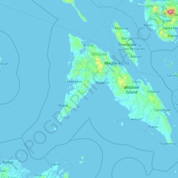
Name: Bangad topographic map, elevation, terrain.
Location: Bangad, Masbate, Bicol Region, Philippines (11.46290 122.70151 12.86290 124.10151)
Average elevation: 17 m
Minimum elevation: -1 m
Maximum elevation: 1,503 m
Other topographic maps
Click on a map to view its topography, its elevation and its terrain.
Calumpang
Philippines > Masbate > Bangad > Calumpang
Calumpang, Bangad, Masbate, Bicol Region, Philippines
Average elevation: 10 m