
Subang Jaya topographic map
Interactive map
Click on the map to display elevation.
About this map
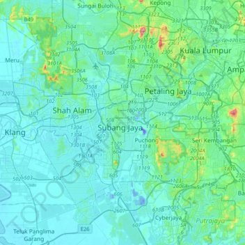
Name: Subang Jaya topographic map, elevation, terrain.
Location: Subang Jaya, Selangor, 47610, Malaysia (2.89675 101.42547 3.21675 101.74547)
Average elevation: 35 m
Minimum elevation: -46 m
Maximum elevation: 323 m
Other topographic maps
Click on a map to view its topography, its elevation and its terrain.
SS16
Malaysia > Selangor > Subang Jaya > SS16
SS16, Subang Jaya, Selangor, 47500, Malaysia
Average elevation: 34 m