
Ganges topographic map
Interactive map
Click on the map to display elevation.
About this map
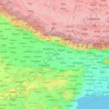
Name: Ganges topographic map, elevation, terrain.
Location: Ganges, Ghāzīpur, Ghazipur, Uttar Pradesh, 249304, India (22.35753 77.99967 30.14509 91.25706)
Average elevation: 1,626 m
Minimum elevation: -2 m
Maximum elevation: 8,096 m
Other topographic maps
Click on a map to view its topography, its elevation and its terrain.
Mall
India > Uttar Pradesh > Malihabad > Mall
Mall, Malihabad, Lucknow, Uttar Pradesh, 227115, India
Average elevation: 125 m
Gairaha
India > Uttar Pradesh > Gairaha
Gairaha, Mauranipur, Jhansi, Uttar Pradesh, India
Average elevation: 225 m
Nizamabad
Nizamabad, Azamgarh, Uttar Pradesh, 276305, India
Average elevation: 81 m
Bareilly
India > Uttar Pradesh > Bareilly
Bareilly, Uttar Pradesh, 243001, India
Average elevation: 169 m
Chandan Chowky
India > Uttar Pradesh > Chandan Chowky
Chandan Chowky, Kheri, Uttar Pradesh, India
Average elevation: 159 m
Mountains
Mountains, Kānpur, Kanpur Dehat, Uttar Pradesh, India
Average elevation: 135 m
Bhinga
India > Uttar Pradesh > Bhinga
Bhinga, Sharawasti, Uttar Pradesh, 271831, India
Average elevation: 120 m