Geolocate

Misamis Occidental topographic map

Click on the map to display elevation.

About this map

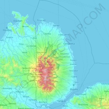
Name: Misamis Occidental topographic map, elevation, terrain.

Location: Misamis Occidental, Northern Mindanao, Philippines (8.00021 123.54032 8.80697 123.99892)

Average elevation: 180 m

Minimum elevation: 0 m

Maximum elevation: 2,375 m

Other topographic maps

Click on a map to view its topography, its elevation and its terrain.

Quezon City

Philippines

Founded as a pueblo by Saint Pedro Bautista in 1590, San Francisco del Monte may be considered Quezon City's oldest district. The original land area of the old town of San Francisco del Monte was approximately2.5 square kilometres (1.0 sq mi) and covered parts of what is currently known as Project 7 and 8 and…

Average elevation: 57 m

Gloria

Philippines > Oriental Mindoro

Average elevation: 12 m

Tarlac

Philippines

Average elevation: 109 m

Upper Agno River Basin

Philippines > Benguet

Average elevation: 1,289 m

Mount Ulap

Philippines > Benguet

Average elevation: 1,479 m

Ocampo

Philippines > Camarines Sur

Average elevation: 87 m

Silang

Philippines > Cavite > Silang

Average elevation: 305 m

Lipa City Community Park

Philippines > Batangas > Lipa > Latag

Average elevation: 311 m

Bagtong

Philippines > Eastern Samar > Salcedo

Average elevation: 16 m

Las Piñas

Philippines

Average elevation: 14 m

Vigan

Philippines > Ilocos Sur

Vigan is situated in a Quaternary Age sedimentary plain called the Vigan-Bantay Plain which is part of the Ilocos coastal plain. The Vigan-Bantay Plain is bounded on the east by a moderately rugged Miocene sediments consisting of interbedded sandstones and shale to very rugged Meta-volcanics and Meta sediment…

Average elevation: 63 m

Marikina

Philippines

Average elevation: 80 m

Iba

Philippines > Zambales

Average elevation: 9 m

Zamboanga del Sur

Philippines

Average elevation: 118 m

Tabogon

Philippines > Cebu

Average elevation: 57 m

Naval

Philippines > Biliran

Average elevation: 31 m

Guiuan

Philippines > Eastern Samar

Average elevation: 6 m

Lapu-Lapu

Philippines

Average elevation: 93 m

Agusan Canyon

Philippines > Bukidnon > Manolo Fortich

Average elevation: 650 m

Compostela

Philippines > Cebu

Average elevation: 26 m

Camarines Sur

Philippines

Average elevation: 56 m

Samar

Philippines

Average elevation: 38 m

Valenzuela

Philippines

The highest elevation point is 38 meters (125 ft) above sea level. Having a surface gradient of 0.55% and a gentle slope, hilly landscape is located in the industrial section of the city in Canumay. The average elevation point is 2 meters (6.6 ft) above sea level.

Average elevation: 24 m

San Pablo

Philippines > Laguna > San Pablo

Average elevation: 220 m

Baguio

Philippines

In 1903, Filipinos, Japanese and Chinese workers were hired to build Kennon Road, the first road directly connecting Baguio with the lowlands of La Union and Pangasinan. Before this, the only road to Benguet was Naguilian Road, and it was largely a horse trail at higher elevations. Camp John Hay was…

Average elevation: 881 m

Cebu City

Philippines > Cebu > Cebu City

Average elevation: 140 m

Purok 7

Philippines > La Union > Bangcusay

Average elevation: 12 m

Quirino

Philippines > La Union > Bacnotan

Average elevation: 16 m

Malagonlong

Philippines > Batangas > Lipa

Average elevation: 273 m

Mount Makiling

Philippines > Laguna > Los Baños

Mount Makiling (also spelled Maquiling) is an inactive stratovolcano located in the provinces of Laguna and Batangas on the island of Luzon in the Philippines. The mountain rises to an elevation of 1,090 meters (3,580 ft) above mean sea level and is the highest feature of the Laguna Volcanic Field. The volcano…

Average elevation: 753 m

Marlangga

Philippines > Marinduque > Torrijos

Average elevation: 232 m

Banawang

Philippines > Bataan > Bagac

Average elevation: 59 m

Atok

Philippines > Benguet

Average elevation: 1,814 m

Muleta River

Philippines > Bukidnon > Kadingilan

Average elevation: 302 m

Cabintan

Philippines > Leyte > Ormoc

Average elevation: 689 m

Dammang

Philippines > Cagayan > Sanchez Mira

Average elevation: 6 m

Talomo District

Philippines > Davao City

Average elevation: 27 m

Mount Mataba

Philippines > Rizal

Average elevation: 279 m

Taguig

Philippines

Average elevation: 39 m

Lourdes

Philippines > Tarlac > Tarlac City

Average elevation: 36 m

Gutalac

Philippines > Zamboanga del Norte

Average elevation: 133 m

Iligan

Philippines

Average elevation: 229 m

Villa Aglipay

Philippines > Tarlac > San Jose

Average elevation: 105 m

Naguilian

Philippines > La Union

The approximate elevation of the municipality is 165 meters above sea level. It has the ninth highest approximate average elevation among the twenty (20) towns of the province. The portion with the highest elevation is 544 meters above sea level while the lowest is 10 meters. The slopes range from 2–7% in…

Average elevation: 85 m

Bacolod

Philippines

Bacólod (English: Bacolod), is derived from bakólod (Old Spelling: bacólod), the Old Hiligaynon (Old Ilonggo) (Old Spelling: Ylongo and Ilongo) word for a "hill, turtle, mound, rise, hillock, down, any small eminence or elevation", since the resettlement was founded on a stony, hilly area, now the barangay…

Average elevation: 49 m

San Isidro

Philippines > Sorsogon

Average elevation: 22 m

Picnic Grove

Philippines > Cavite > Tagaytay

Average elevation: 474 m

Milaor

Philippines > Camarines Sur

Average elevation: 5 m

Tubungan

Philippines > Iloilo

Tubungan is 41 kilometres (25 mi) from Iloilo City. With a land area of 8,518 hectares (21,050 acres) found a hundred feet above sea level, the municipality's topography is dominated mostly by gentle rolling hills and idyllic mountains. The slope gradient ranges to as high as 25 per cent in most areas giving…

Average elevation: 153 m

Salcedo

Philippines > Eastern Samar

Average elevation: 28 m

Kabayan

Philippines > Benguet

Average elevation: 1,578 m

Iraya (Del Rosario)

Philippines > Camarines Sur

Average elevation: 157 m

Dapitan River

Philippines > Zamboanga del Norte

Average elevation: 293 m

Guiuan

Philippines > Eastern Samar

Average elevation: 6 m

Bamban

Philippines > Tarlac

Average elevation: 375 m

Batanes

Philippines

Average elevation: 26 m

Bohol

Philippines

Average elevation: 116 m

Cebu

Philippines

Average elevation: 89 m

Rizal

Philippines

Average elevation: 95 m

Angat Dam

Philippines > Bulacan

Average elevation: 254 m

Jabonga

Philippines > Agusan del Norte

The topography of the land features plain to rolling and hills. Among the municipalities, Jabonga ranks first in total area and number of farms (464) mostly owned by individuals. It has one of the 36 crop storage facilities of the province. Its major crops are coconut, rice, corn, timber and both fresh and…

Average elevation: 116 m

Mount Banahaw

Philippines > Quezon > Tayabas

The andesitic Banahaw volcanic complex is composed of several stratovolcanoes with Mount Banahaw, the largest with a maximum elevation of 2,170 metres (7,119 ft) above mean sea level. The summit is topped by a 1.5 by 3.5 kilometres (0.93 mi × 2.17 mi) and 210 metres (690 ft) deep crater that is breached on…

Average elevation: 1,730 m

Malabon

Philippines > Malabon > Malabon

Average elevation: 17 m

Mandaue

Philippines

It is one of the two (the other one being the municipality of Consolacion) local government units located within the mainland Metro Cebu where the elevation of land is less than 100 m (330 ft).

Average elevation: 109 m

Hermosa

Philippines > Bataan

Average elevation: 17 m

Mauban

Philippines > Quezon

Average elevation: 43 m

Lal-lo

Philippines > Cagayan

Average elevation: 18 m

Norzagaray

Philippines > Bulacan

Average elevation: 66 m

Tagum

Philippines > Davao del Norte

One of the significant accomplishments of the officialdom of Tagum during the 1990s was its elevation from a second to the first-class municipality. This opened a gateway to increase its financial resources through the Internal Revenue Allocation (IRA) from the national government and local revenues. This was…

Average elevation: 103 m

Malolos

Philippines > Bulacan

Malolos is relatively flat of about 0.81% to a gently sloping of 2.17%. The slope of the land descends towards west, southwest to southern direction. The highest land elevation is at about 6.0 meters above sea level while the lowest is only half a meter below sea level. A network of natural waterways and…

Average elevation: 6 m

Zamboanga City

Philippines > Zamboanga Peninsula > Zamboanga City

The overall topography of the city could be described as rolling to very steep. There are some flat lands, mostly narrow strips along the east coast. The urban center is mostly flat with a gentle slope to the interior, ranging from 0 to 3%. The highest registered elevation is 1,200 metres. In terms of slope, a…

Average elevation: 83 m

Patag Island

Philippines

Average elevation: 0 m

Kota Island

Philippines

Average elevation: 0 m

Lankiam Cay

Philippines

Average elevation: 0 m

Davao Gulf

Philippines

Average elevation: 0 m

Lawak Island

Philippines

Average elevation: 0 m

Angeles

Philippines > Pampanga

Sapangbato is the largest barangay in Angeles in terms of territory, with a total land area of 104,694 sq. meters and a population of 11,262. Located northwest of Angeles near Clark Freeport Zone, it is identified as the barangay in Angeles with the highest elevation of 750 feet above sea level. It is home to…

Average elevation: 128 m

Surigao del Sur

Philippines

Average elevation: 274 m

Candaba

Philippines

Average elevation: 6 m

Davao City

Philippines

Average elevation: 65 m

Kinatihan II

Philippines

Average elevation: 22 m

Culandanum

Philippines > Palawan

Average elevation: 27 m

Ibabang Bukal

Philippines

Average elevation: 254 m

Cabatang

Philippines

Average elevation: 335 m

Pinget

Philippines

Average elevation: 1,430 m

Caloocan

Philippines

Average elevation: 81 m

Aurora Hill North Central

Philippines

Average elevation: 1,479 m

Baracatan

Philippines

Average elevation: 357 m

Besigan

Philippines

Average elevation: 584 m

Talomo River

Philippines

Average elevation: 201 m

Asin

Philippines

Average elevation: 1,321 m

Catambungan

Philippines

Average elevation: 5 m

Tablas Strait

Philippines

Average elevation: 0 m

Buenavista

Philippines

Average elevation: 112 m

Poliwes

Philippines

Average elevation: 1,397 m

Teodora Alonzo

Philippines

Average elevation: 1,459 m

Manggahan

Philippines

Average elevation: 7 m

Bakakeng Norte

Philippines

Average elevation: 1,379 m