
Kotkot Island topographic map
Interactive map
Click on the map to display elevation.
About this map
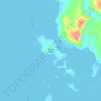
Name: Kotkot Island topographic map, elevation, terrain.
Average elevation: 8 m
Minimum elevation: -2 m
Maximum elevation: 99 m
Other topographic maps
Click on a map to view its topography, its elevation and its terrain.
Kanhatid Island
Philippines > Dinagat Islands > Puerto Princesa
Kanhatid Island, Puerto Princesa, Dinagat Islands, Caraga, Philippines
Average elevation: 7 m
Kanhanusa Island
Philippines > Dinagat Islands > Puerto Princesa
Kanhanusa Island, Puerto Princesa, Dinagat Islands, Caraga, Philippines
Average elevation: 2 m