
Glan topographic map
Interactive map
Click on the map to display elevation.
About this map
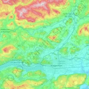
Name: Glan topographic map, elevation, terrain.
Location: Glan, Bezirk Feldkirchen, Carinthia, Austria (46.60312 14.05787 46.76334 14.42568)
Average elevation: 630 m
Minimum elevation: 398 m
Maximum elevation: 1,333 m
Other topographic maps
Click on a map to view its topography, its elevation and its terrain.
Krems in Kärnten
Austria > Carinthia > Krems in Kärnten
Krems in Kärnten, Spittal an der Drau, Carinthia, Austria
Average elevation: 1,707 m
Ankogel Group
Ankogel Group, Malta, Spittal an der Drau, Carinthia, 9854, Austria
Average elevation: 1,683 m
Großglockner
Austria > Carinthia > Heiligenblut am Großglockner
Großglockner, Heiligenblut am Großglockner, Spittal an der Drau, Carinthia, Austria
Average elevation: 3,128 m