
Evans County topographic map
Interactive map
Click on the map to display elevation.
About this map
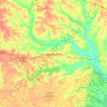
Name: Evans County topographic map, elevation, terrain.
Location: Evans County, Georgia, United States of America (32.04790 -82.02575 32.27889 -81.71866)
Average elevation: 47 m
Minimum elevation: 19 m
Maximum elevation: 78 m
Air travel in Evans County is provided by the Claxton-Evans County Airport. The site for the airport was approved by the FAA in 1964 and it was activated in 1971; the airport is three miles (5 km) northeast of Claxton, Georgia. It is operated by the city of Claxton. It has a 5,000-foot (1,500 m) runway, hangars, pilot control lighting, and a Precision Approach Path Indicator. The Claxton-Evans County Airport has an elevation of 112 ft (34.1 m).
Other topographic maps
Click on a map to view its topography, its elevation and its terrain.
Murray County
United States of America > Georgia
Murray County, Georgia, United States of America
Average elevation: 381 m
Coffee County
United States of America > Georgia
Coffee County, Georgia, United States of America
Average elevation: 72 m
Bibb County
United States of America > Georgia
Bibb County, Georgia, United States of America
Average elevation: 128 m