
Alpes-de-Haute-Provence topographic map
Interactive map
Click on the map to display elevation.
About this map
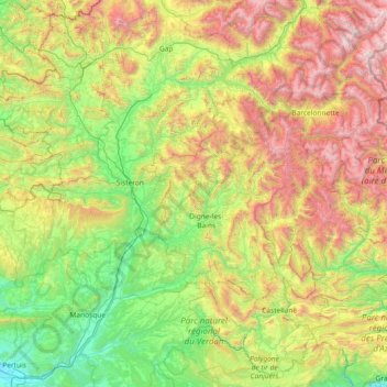
Name: Alpes-de-Haute-Provence topographic map, elevation, terrain.
Average elevation: 1,141 m
Minimum elevation: 177 m
Maximum elevation: 3,366 m
Other topographic maps
Click on a map to view its topography, its elevation and its terrain.
Aurafrède
France > Provence-Alpes-Côte d'Azur > Alpes-de-Haute-Provence > Gréoux-les-Bains
Average elevation: 389 m
Cime de la Bonette
France > Provence-Alpes-Côte d'Azur > Maritime Alps > Saint-Dalmas-le-Selvage
Average elevation: 2,512 m