
Murray County topographic map
Interactive map
Click on the map to display elevation.
About this map
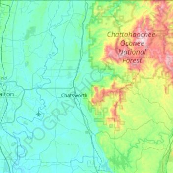
Name: Murray County topographic map, elevation, terrain.
Location: Murray County, Georgia, United States of America (34.58369 -84.94451 34.98839 -84.58493)
Average elevation: 381 m
Minimum elevation: 188 m
Maximum elevation: 1,252 m
Other topographic maps
Click on a map to view its topography, its elevation and its terrain.
Evans County
United States of America > Georgia
Evans County, Georgia, United States of America
Average elevation: 47 m
Coffee County
United States of America > Georgia
Coffee County, Georgia, United States of America
Average elevation: 72 m
Bibb County
United States of America > Georgia
Bibb County, Georgia, United States of America
Average elevation: 128 m