
Corregidor Island topographic map
Interactive map
Click on the map to display elevation.
About this map
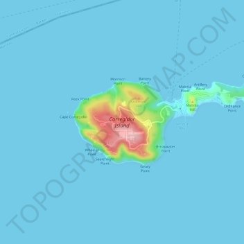
Name: Corregidor Island topographic map, elevation, terrain.
Average elevation: 11 m
Minimum elevation: -1 m
Maximum elevation: 180 m
The tadpole-shaped island, with its tail running eastward, is about 6.5 km (4.0 mi) long, about 2.0 km (1.2 mi) wide at its widest with a total land area of about 900 hectares (2,200 acres). The highest elevation is at 180 m (590 ft) on the Topside. The island is divided into four sections:
Other topographic maps
Click on a map to view its topography, its elevation and its terrain.
La Monja Island
Philippines > Cavite > Cavite City
La Monja Island, Cavite City, Cavite, Calabarzon, 4100, Philippines
Average elevation: 0 m
Santa Amalia Rock
Philippines > Cavite > Cavite City
Santa Amalia Rock, Cavite City, Cavite, Calabarzon, 4100, Philippines
Average elevation: 67 m