
Schierke topographic map
Interactive map
Click on the map to display elevation.
About this map
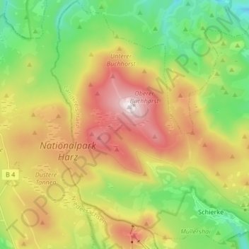
Name: Schierke topographic map, elevation, terrain.
Average elevation: 767 m
Minimum elevation: 490 m
Maximum elevation: 1,142 m
Other topographic maps
Click on a map to view its topography, its elevation and its terrain.
Bielstein
Duitsland > Saksen-Anhalt > Wernigerode
Bielstein, Wernigerode, Landkreis Harz, Saksen-Anhalt, 38831, Duitsland
Average elevation: 474 m