
Grisons topographic map
Interactive map
Click on the map to display elevation.
About this map
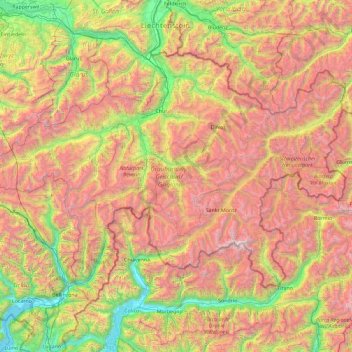
Name: Grisons topographic map, elevation, terrain.
Location: Grisons, Switzerland (46.16918 8.65106 47.06515 10.49229)
Average elevation: 1,737 m
Minimum elevation: 189 m
Maximum elevation: 4,001 m
The Grisons lies fully within the Alps, with elevations above sea-level ranging from 260 to 4,049 metres (853 to 13,284 ft). It is both one of the highest and lowest cantons, and the second-highest when considering mean elevation. As a consequence, its topography is extremely rugged and many of the highest settlements in the country (and Europe) are found there, notably in the Upper Engadin. The mountains are numerous; well over 1,000 summits are in the canton. The highest is Piz Bernina, closely followed by numerous peaks in the homonymous range. Other prominent mountains are Piz Russein, Piz Kesch, Calanda, Aroser Rothorn and Rheinwaldhorn, see list of mountains of Graubünden for a more exhaustive list. The canton includes numerous subranges of the Alps other than the Bernina. These are the Albula, the Bregaglia, the Glarus, the Gotthard, the Lepontine, the Livigno, the Plessur, the Oberhalbstein, the Ortler, the Rätikon, the Samnaun, the Sesvenna and the Silvretta ranges.
Other topographic maps
Click on a map to view its topography, its elevation and its terrain.
Brè
Switzerland > Ticino > Distretto di Lugano > Lugano
Brè, Circolo di Lugano est, Lugano, Distretto di Lugano, Ticino, 6979, Switzerland
Average elevation: 564 m
Locarno
Switzerland > Ticino > Distretto di Locarno
Locarno, Circolo di Locarno, Distretto di Locarno, Ticino, Switzerland
Average elevation: 608 m
Brè sopra Locarno
Switzerland > Ticino > Distretto di Locarno > Locarno
Brè sopra Locarno, Locarno, Circolo di Locarno, Distretto di Locarno, Ticino, 6605, Switzerland
Average elevation: 659 m
Zurich
Switzerland > Zurich > District Zurich
Zurich, District Zurich, Zurich, Switzerland
Average elevation: 499 m
Usc
Switzerland > Ticino > Distretto di Leventina > Sobrio
Usc, Sobrio, Faido, Circolo di Faido, Distretto di Leventina, Ticino, 6749, Switzerland
Average elevation: 1,325 m
Kiental
Switzerland > Bern > Frutigen-Niedersimmental administrative district > Reichenbach im Kandertal
Kiental, Reichenbach im Kandertal, Frutigen-Niedersimmental administrative district, Oberland administrative region, Bern, 3723, Switzerland
Average elevation: 1,363 m
Lauenen
Switzerland > Bern > Obersimmental-Saanen administrative district
Lauenen, Obersimmental-Saanen administrative district, Oberland administrative region, Bern, 3782, Switzerland
Average elevation: 1,882 m
Val de Bagnes
Switzerland > Wallis > Entremont
Val de Bagnes, Entremont, Wallis, 1934, Switzerland
Average elevation: 2,321 m
Rickenbach
Switzerland > Schwyz > Schwyz > Schwyz > Rickenbach
Rickenbach, Schwyz, 6432, Switzerland
Average elevation: 751 m
Courtelary
Switzerland > Bern > Bernese Jura administrative district
Courtelary, Bernese Jura administrative district, Bernese Jura administrative region, Bern, 2608, Switzerland
Average elevation: 1,059 m
Fribourg - Freiburg
Switzerland > Fribourg > Fribourg - Freiburg
Fribourg - Freiburg, Sarine District, Fribourg, Switzerland
Average elevation: 638 m
Bern
Switzerland > Bern > Bern-Mittelland administrative district
Bern, Bern-Mittelland administrative district, Bernese Mittelland administrative region, Bern, Switzerland
Average elevation: 612 m
Hinterrhein
Switzerland > Grisons > Rhäzüns
Hinterrhein, Hauptstrasse, Alp Sura, Rhäzüns, Imboden, Grisons, 7403, Switzerland
Average elevation: 839 m
Wangen (SZ)
Switzerland > Schwyz > Wangen (SZ)
Wangen (SZ), March, Schwyz, 8855, Switzerland
Average elevation: 432 m
Zernez
Switzerland > Grisons > Zernez
Zernez, Region Engiadina Bassa/Val Müstair, Grisons, Switzerland
Average elevation: 2,297 m
Breithorn
Switzerland > Valais/Wallis > Blatten
Breithorn, Blatten, Westlich Raron, Valais/Wallis, 3919, Switzerland
Average elevation: 2,914 m
Neuhausen am Rheinfall
Switzerland > Schaffhausen > Neuhausen am Rheinfall
Neuhausen am Rheinfall, Schaffhausen, 8212, Switzerland
Average elevation: 456 m
Rapperswil
Switzerland > Sankt Gallen > Rapperswil
Rapperswil, Wahlkreis See-Gaster, Sankt Gallen, 8640, Switzerland
Average elevation: 448 m
Laupen
Switzerland > Bern > Laupen
Laupen, Verwaltungskreis Bern-Mittelland, Verwaltungsregion Bern-Mittelland, Bern, 3177, Switzerland
Average elevation: 531 m
Wohlen
Switzerland > Aargau > Wohlen
Wohlen, Bezirk Bremgarten, Aargau, Switzerland
Average elevation: 445 m
Sonogno
Switzerland > Ticino > Sonogno
Sonogno, Circolo della Verzasca, Distretto di Locarno, Ticino, 6637, Switzerland
Average elevation: 1,816 m
Diemtigen
Switzerland > Bern > Diemtigen
Diemtigen, Verwaltungskreis Frutigen-Niedersimmental, Verwaltungsregion Oberland, Bern, 3754, Switzerland
Average elevation: 1,445 m
Cevio
Switzerland > Ticino > Cevio
Cevio, Circolo della Rovana, Distretto di Vallemaggia, Ticino, Switzerland
Average elevation: 1,781 m
Les Vernettes
Switzerland > Vaud > Bioley-Magnoux
Les Vernettes, Bioley-Magnoux, District du Jura-Nord vaudois, Vaud, 1045, Switzerland
Average elevation: 649 m
Schänis
Switzerland > Sankt Gallen > Schänis
Schänis, Wahlkreis See-Gaster, Sankt Gallen, Switzerland
Average elevation: 725 m
San Giorgio
Switzerland > Ticino > Origlio
San Giorgio, Origlio, Circolo di Capriasca, Distretto di Lugano, Ticino, 6945, Switzerland
Average elevation: 453 m
Le Chenit
Switzerland > Vaud > Le Chenit
Le Chenit, District du Jura-Nord vaudois, Vaud, Switzerland
Average elevation: 1,239 m
Liddes
Switzerland > Valais/Wallis > Liddes
Liddes, Entremont, Valais/Wallis, 1945, Switzerland
Average elevation: 2,123 m
Sur le Mont
Switzerland > Vaud > Orny
Sur le Mont, Orny, District de Morges, Vaud, 1315, Switzerland
Average elevation: 482 m
Islas
Switzerland > Grisons > Zuoz
Islas, Zuoz, Maloja, Grisons, 7524, Switzerland
Average elevation: 1,812 m
Nadelhorn
Switzerland > Valais/Wallis > Randa
Nadelhorn, Randa, Visp, Valais/Wallis, 3928, Switzerland
Average elevation: 3,765 m
Theodulgletscher
Switzerland > Valais/Wallis > Zermatt
Theodulgletscher, Klein Matterhorn, Trockener Steg, Zermatt, Visp, Valais/Wallis, 3920, Switzerland
Average elevation: 3,228 m
Alphubel
Switzerland > Valais/Wallis > Täsch
Alphubel, Täsch, Visp, Valais/Wallis, 3929, Switzerland
Average elevation: 3,614 m
Balmhorn
Switzerland > Bern > Kandersteg
Balmhorn, Kandersteg, Verwaltungskreis Frutigen-Niedersimmental, Verwaltungsregion Oberland, Bern, 3718, Switzerland
Average elevation: 2,955 m
Lauteraarhorn
Switzerland > Bern > Guttannen
Lauteraarhorn, Guttannen, Verwaltungskreis Interlaken-Oberhasli, Verwaltungsregion Oberland, Bern, 3864, Switzerland
Average elevation: 3,313 m
Nendaz
Switzerland > Valais/Wallis > Nendaz
Nendaz, Conthey, Valais/Wallis, 1997, Switzerland
Average elevation: 1,771 m
Dufourspitze (Monte Rosa)
Switzerland > Valais/Wallis > Zermatt
Dufourspitze (Monte Rosa), Zermatt, Visp, Valais/Wallis, 3920, Switzerland
Average elevation: 4,033 m
Piz Corvatsch
Switzerland > Grisons > Sils im Engadin/Segl
Piz Corvatsch, Sils im Engadin/Segl, Maloja, Grisons, Switzerland
Average elevation: 2,931 m
Lenzspitze
Switzerland > Valais/Wallis > Saas-Fee
Lenzspitze, Saas-Fee, Visp, Valais/Wallis, 3906, Switzerland
Average elevation: 3,714 m
Bishorn
Switzerland > Valais/Wallis > Turtmann-Unterems
Bishorn, Turtmann-Unterems, Leuk, Valais/Wallis, 3948, Switzerland
Average elevation: 3,597 m
Ober Gabelhorn
Switzerland > Valais/Wallis > Zermatt
Ober Gabelhorn, Zermatt, Visp, Valais/Wallis, 3920, Switzerland
Average elevation: 3,320 m
Swiss National Park
Switzerland > Grisons > Zernez
Swiss National Park, 28, Punt la Drossa, Zernez, Region Engiadina Bassa/Val Müstair, Grisons, 7530, Switzerland
Average elevation: 2,283 m
Finsteraarhorn
Switzerland > Valais/Wallis > Fieschertal
Finsteraarhorn, Fieschertal, Goms, Valais/Wallis, Switzerland
Average elevation: 3,420 m
Matterhorn
Switzerland > Valais/Wallis > Zermatt
Matterhorn, Zermatt, Visp, Valais/Wallis, 3920, Switzerland
Average elevation: 3,296 m