
Livingston Island topographic map
Interactive map
Click on the map to display elevation.
About this map
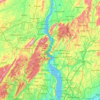
Name: Livingston Island topographic map, elevation, terrain.
Average elevation: 156 m
Minimum elevation: -2 m
Maximum elevation: 501 m
Other topographic maps
Click on a map to view its topography, its elevation and its terrain.
Samuel F. Pryor III Shawangunk Gateway Campground
USA > New York > Wallkill Camp
Samuel F. Pryor III Shawangunk Gateway Campground, Wallkill Camp, Town of Gardiner, Ulster County, New York, USA
Average elevation: 171 m
Staten Island
Staten Island, Richmond County, New York, USA
Average elevation: 11 m
City of Saratoga Springs
USA > New York > City of Saratoga Springs
City of Saratoga Springs, Saratoga County, New York, USA
Average elevation: 95 m
Mendon Center
USA > New York > Mendon Center
Mendon Center, Mendon Town, Monroe County, New York, 14472, USA
Average elevation: 197 m
Sawtooth Mountains
Sawtooth Mountains, Franklin County, New York, USA
Average elevation: 927 m
Flat Top Mountain
Flat Top Mountain, Franklin County, New York, USA
Average elevation: 568 m
American Falls
USA > New York > Niagara Falls
American Falls, Niagara Falls, Niagara County, New York, NY 14303, USA
Average elevation: 170 m
Pirate Island
USA > New York > Town of Lewisboro
Pirate Island, Town of Lewisboro, Westchester County, New York, USA
Average elevation: 171 m
Barren Island
USA > New York > New York City
Barren Island, Kings County, New York City, New York, 11697, USA
Average elevation: 16 m
Midtown East
USA > New York > New York City
Midtown East, Manhattan, Manhattan Community Board 5, New York County, New York City, New York, USA
Average elevation: 22 m
Roosevelt Island
USA > New York > New York City
Roosevelt Island, Manhattan Community Board 8, New York County, New York City, New York, 10044, USA
Average elevation: 13 m
Mount Warren
Mount Warren, Town of Bovina, Delaware County, New York, USA
Average elevation: 677 m
Buchanan
USA > New York > Buchanan > Town of Cortlandt
Buchanan, Town of Cortlandt, Westchester County, New York, 10511, USA
Average elevation: 27 m
Falls Creek
Falls Creek, Town of Delhi, Delaware County, New York, 13753, USA
Average elevation: 515 m
Big Bear Mountain
Big Bear Mountain, Town of Johnsburg, Warren County, New York, USA
Average elevation: 616 m
Lenox Hill
USA > New York > New York City
Lenox Hill, Manhattan, Manhattan Community Board 8, New York County, New York City, New York, USA
Average elevation: 21 m
Cascade Mountain
Cascade Mountain, Town of Long Lake, Hamilton County, New York, USA
Average elevation: 585 m
Chinatown
USA > New York > New York City
Chinatown, Manhattan, Manhattan Community Board 2, New York County, New York City, New York, USA
Average elevation: 12 m
Twin Island
USA > New York > New York City
Twin Island, Bronx County, New York City, New York, 10464, USA
Average elevation: 41 m
Avalanche Lake
Avalanche Lake, Avalanche Pass Trail, Essex County, New York, USA
Average elevation: 1,066 m