
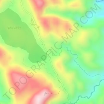
Binahaan River topographic map
Interactive map
Click on the map to display elevation.
About this map
Name: Binahaan River topographic map, elevation, terrain.
Average elevation: 681 m
Minimum elevation: 499 m
Maximum elevation: 870 m
Other topographic maps
Click on a map to view its topography, its elevation and its terrain.
Salvacion
Philippines > Leyte > Ormoc
Salvacion, Ormoc, 4th District, Leyte, Eastern Visayas, 6541, Philippines
Average elevation: 41 m
Ormoc
Philippines > Leyte > Ormoc
Ormoc, Leyte 4th District, Leyte, Eastern Visayas, 6541, Philippines
Average elevation: 204 m
Cabintan
Philippines > Leyte > Ormoc
Cabintan, Ormoc, 4th District, Leyte, Eastern Visayas, 6541, Philippines
Average elevation: 689 m
Mahayahay
Philippines > Leyte > Ormoc
Mahayahay, Ormoc, 4th District, Leyte, Eastern Visayas, Philippines
Average elevation: 169 m
Danao
Philippines > Leyte > Ormoc
Danao, Ormoc, Leyte 4th District, Leyte, Eastern Visayas, 6541, Philippines
Average elevation: 704 m
Tambulilid
Philippines > Leyte > Ormoc
Tambulilid, Ormoc, Leyte 4th District, Leyte, Eastern Visayas, 6541, Philippines
Average elevation: 8 m
Lake Danao
Philippines > Leyte > Ormoc > Danao
Lake Danao, Danao, Ormoc, 4th District, Leyte, Eastern Visayas, 6541, Philippines
Average elevation: 729 m
Maagonoc
Philippines > Leyte > Ormoc
Maagonoc, Ormoc, Leyte 4th District, Leyte, Eastern Visayas, 6541, Philippines
Average elevation: 434 m
Mount Janagdan
Philippines > Leyte > Ormoc
Mount Janagdan, Ormoc, Leyte 4th District, Leyte, Eastern Visayas, 6541, Philippines
Average elevation: 867 m