
Peniel topographic map
Interactive map
Click on the map to display elevation.
About this map
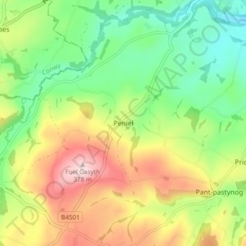
Name: Peniel topographic map, elevation, terrain.
Location: Peniel, Denbighshire, Wales, LL16 4TD, United Kingdom (53.13524 -3.47189 53.17524 -3.43189)
Average elevation: 196 m
Minimum elevation: 72 m
Maximum elevation: 374 m
Other topographic maps
Click on a map to view its topography, its elevation and its terrain.
Peniel
United Kingdom > Wales > Peniel
Peniel, Carmarthenshire, Wales, United Kingdom
Average elevation: 94 m