
Horsens Municipality topographic map
Interactive map
Click on the map to display elevation.
About this map
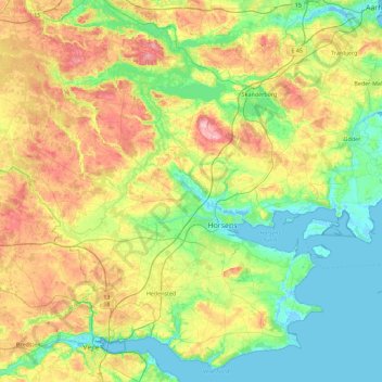
Name: Horsens Municipality topographic map, elevation, terrain.
Location: Horsens Municipality, Central Denmark Region, Denmark (55.74146 9.46234 56.07005 10.36680)
Average elevation: 57 m
Minimum elevation: -4 m
Maximum elevation: 176 m
Other topographic maps
Click on a map to view its topography, its elevation and its terrain.
Jutland
Denmark > Central Denmark Region > Jutland
Jutland, Ikast-Brande Municipality, Central Denmark Region, Denmark
Average elevation: 11 m
Møllehøj
Denmark > Central Denmark Region > Jutland
Møllehøj, Lindbjergvej, Jutland, Skanderborg Municipality, Central Denmark Region, 8751, Denmark
Average elevation: 131 m
Skanderborg Municipality
Denmark > Central Denmark Region
Skanderborg Municipality, Central Denmark Region, Denmark
Average elevation: 66 m
Ejer Bavnehøj
Denmark > Central Denmark Region
Ejer Bavnehøj, Skanderborg Municipality, Central Denmark Region, 8751, Denmark
Average elevation: 128 m
Horsens
Denmark > Central Denmark Region > Horsens
Horsens, Horsens Municipality, Central Denmark Region, 8700, Denmark
Average elevation: 51 m