
Beervelde topographic map
Interactive map
Click on the map to display elevation.
About this map
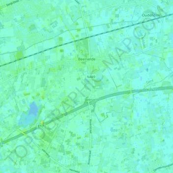
Name: Beervelde topographic map, elevation, terrain.
Location: Beervelde, Lochristi, Gent, Oost-Vlaanderen, België (51.05031 3.83450 51.09237 3.92320)
Average elevation: 6 m
Minimum elevation: 2 m
Maximum elevation: 13 m
Beervelde ligt in Zandig Vlaanderen op een hoogte van 5-7 meter. Kenmerkend is de aardbeienteelt die omstreeks 1900 tot ontwikkeling kwam.
Other topographic maps
Click on a map to view its topography, its elevation and its terrain.
Lobos
België > Oost-Vlaanderen > Gent > Lochristi
Lobos, Lochristi, Gent, Oost-Vlaanderen, 9080, België
Average elevation: 6 m
Lochristi
België > Oost-Vlaanderen > Gent > Lochristi
Lochristi, Gent, Oost-Vlaanderen, 9080, België
Average elevation: 6 m
Lozen Boer
België > Oost-Vlaanderen > Gent > Lochristi
Lozen Boer, Lochristi, Gent, Oost-Vlaanderen, 9080, België
Average elevation: 5 m
Zaffelare
België > Oost-Vlaanderen > Gent > Lochristi
Zaffelare, Lochristi, Gent, Oost-Vlaanderen, België
Average elevation: 5 m
Zeveneken
België > Oost-Vlaanderen > Gent > Lochristi
Zeveneken, Lochristi, Gent, Oost-Vlaanderen, Vlaanderen, België
Average elevation: 5 m
Hijfte
België > Oost-Vlaanderen > Gent > Lochristi
Hijfte, Lochristi, Gent, Oost-Vlaanderen, Vlaanderen, 9080, België
Average elevation: 6 m