
Mulanje topographic map
Interactive map
Click on the map to display elevation.
About this map
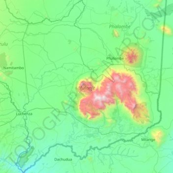
Name: Mulanje topographic map, elevation, terrain.
Location: Mulanje, Southern Region, Malawi, Malawi (-16.21758 35.27893 -15.59863 35.81926)
Average elevation: 803 m
Minimum elevation: 382 m
Maximum elevation: 2,962 m
Other topographic maps
Click on a map to view its topography, its elevation and its terrain.
Lake Chilwa
Lake Chilwa, Zomba, Southern Region, Malawi
Average elevation: 647 m