
Brussels-Capital topographic map
Interactive map
Click on the map to display elevation.
About this map
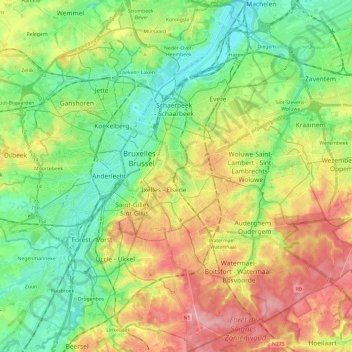
Name: Brussels-Capital topographic map, elevation, terrain.
Location: Brussels-Capital, Belgium (50.76368 4.24377 50.91390 4.48227)
Average elevation: 62 m
Minimum elevation: 10 m
Maximum elevation: 140 m
Brussels lies in the north-central part of Belgium, about 110 km (68 mi) from the Belgian coast and about 180 km (110 mi) from Belgium's southern tip. It is located in the heartland of the Brabantian Plateau, about 45 km (28 mi) south of Antwerp (Flanders), and 50 km (31 mi) north of Charleroi (Wallonia). Its average elevation is 57 m (187 ft) above sea level, varying from a low point in the valley of the almost completely covered Senne, which cuts the Brussels-Capital Region from east to west, up to high points in the Sonian Forest, on its southeastern side. In addition to the Senne, tributary streams such as the Maalbeek and the Woluwe, to the east of the region, account for significant elevation differences. Brussels' central boulevards are 15 m (49 ft) above sea level. Contrary to popular belief, the highest point (at 127.5 m (418 ft)) is not near the Place de l'Altitude Cent/Hoogte Honderdplein in Forest, but at the Drève des Deux Montages/Tweebergendreef in the Sonian Forest.
Other topographic maps
Click on a map to view its topography, its elevation and its terrain.
Anderlecht
Anderlecht, Brussels-Capital, 1070, Belgium
Average elevation: 51 m
Petit-Axhe
Belgium > Liège > Waremme > Waremme
Petit-Axhe, Waremme, Liège, Wallonia, 4300, Belgium
Average elevation: 125 m
Brussels
Belgium > Brussels-Capital > Brussels
Brussels, Brussels-Capital, Belgium
Average elevation: 54 m
Ottignies-Louvain-la-Neuve
Belgium > Wallonia > Ottignies-Louvain-la-Neuve
Ottignies-Louvain-la-Neuve, Nivelles, Walloon Brabant, Wallonia, Belgium
Average elevation: 103 m
Sambreville
Belgium > Wallonia > Sambreville
Sambreville, Namur, Wallonia, 5060, Belgium
Average elevation: 139 m
Oudsbergen
Belgium > Flanders > Oudsbergen
Oudsbergen, Maaseik, Limburg, Flanders, Belgium
Average elevation: 70 m
Le Train
Belgium > Wallonia > Grez-Doiceau
Le Train, Grez-Doiceau, Nivelles, Walloon Brabant, Wallonia, 1390, Belgium
Average elevation: 63 m