
Općina Brod Moravice topographic map
Interactive map
Click on the map to display elevation.
About this map
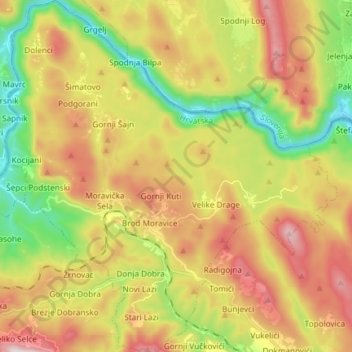
Name: Općina Brod Moravice topographic map, elevation, terrain.
Average elevation: 530 m
Minimum elevation: 185 m
Maximum elevation: 927 m
Other topographic maps
Click on a map to view its topography, its elevation and its terrain.
Šepci Podstenski
Croatia > Primorje-Gorski Kotar County
Šepci Podstenski, Općina Brod Moravice, Primorje-Gorski Kotar County, 51312, Croatia
Average elevation: 433 m