
Islay topographic map
Interactive map
Click on the map to display elevation.
About this map
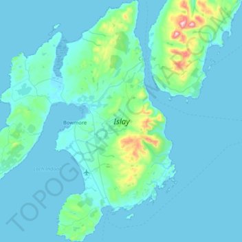
Name: Islay topographic map, elevation, terrain.
Location: Islay, Argyll and Bute, Scotland, United Kingdom (55.57907 -6.52575 55.93809 -6.01981)
Average elevation: 53 m
Minimum elevation: -1 m
Maximum elevation: 769 m
Other topographic maps
Click on a map to view its topography, its elevation and its terrain.
North Connel
United Kingdom > Scotland > Argyll and Bute
North Connel, Argyll and Bute, Scotland, PA37 1PL, United Kingdom
Average elevation: 19 m