
Kota Kinabalu topographic map
Interactive map
Click on the map to display elevation.
About this map
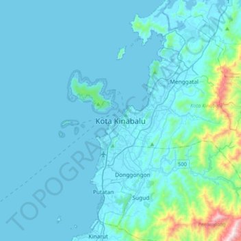
Name: Kota Kinabalu topographic map, elevation, terrain.
Location: Kota Kinabalu, Sabah, 88000, Malaysia (5.81801 115.91290 6.13801 116.23290)
Average elevation: 86 m
Minimum elevation: -2 m
Maximum elevation: 1,093 m
Other topographic maps
Click on a map to view its topography, its elevation and its terrain.
Gaya Island
Malaysia > Sabah > Kota Kinabalu
Gaya Island, Kota Kinabalu, Sabah, Malaysia
Average elevation: 34 m