
Jersey City topographic map
Interactive map
Click on the map to display elevation.
About this map
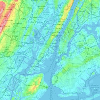
Name: Jersey City topographic map, elevation, terrain.
Location: Jersey City, Hudson County, New Jersey, 07302, United States (40.56157 -74.20746 40.88157 -73.88746)
Average elevation: 21 m
Minimum elevation: -7 m
Maximum elevation: 209 m
Other topographic maps
Click on a map to view its topography, its elevation and its terrain.
Marion
United States > New Jersey > Hudson County > Jersey City
Marion, Jersey City, Hudson County, New Jersey, 07306, United States
Average elevation: 12 m