
Great Sitkin Island topographic map
Interactive map
Click on the map to display elevation.
About this map
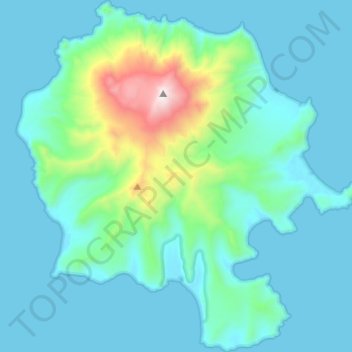
Name: Great Sitkin Island topographic map, elevation, terrain.
Average elevation: 211 m
Minimum elevation: -2 m
Maximum elevation: 1,726 m
Other topographic maps
Click on a map to view its topography, its elevation and its terrain.
Flora Island
United States > Alaska > Unorganized Borough
Flora Island, Unorganized Borough, Alaska, United States
Average elevation: 59 m
Denali's Fault. Scenic overlook
United States > Alaska > Unorganized Borough > Delta Junction
Denali's Fault. Scenic overlook, Richardson Highway, Delta Junction, Unorganized Borough, Alaska, 99731, United States
Average elevation: 379 m
Bethel
United States > Alaska > Unorganized Borough > Bethel
Bethel, Unorganized Borough, Alaska, 99559, United States
Average elevation: 11 m