
Carroll County topographic map
Interactive map
Click on the map to display elevation.
About this map
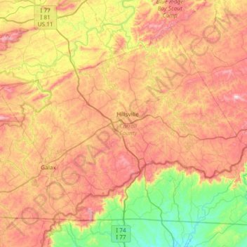
Name: Carroll County topographic map, elevation, terrain.
Location: Carroll County, Virginia, United States (36.55791 -81.04243 36.93178 -80.45377)
Average elevation: 709 m
Minimum elevation: 313 m
Maximum elevation: 1,181 m
It is the only county in Virginia with Piedmont topography of roughly one fifth in the southeast part of the county and mountain topography of roughly four fifths elsewhere of the county. The Blue Ridge escarpment usually defines the county lines in both North Carolina and Virginia. The CDP community of Cana is in the Virginia Piedmont while the rest of the county is in the Appalachian Mountains.