
Sipocot topographic map
Interactive map
Click on the map to display elevation.
About this map
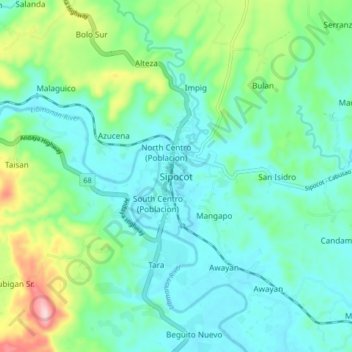
Name: Sipocot topographic map, elevation, terrain.
Location: Sipocot, Camarines Sur, Bicol Region, 4408, Philippines (13.72664 122.93858 13.80664 123.01858)
Average elevation: 61 m
Minimum elevation: 3 m
Maximum elevation: 252 m
Other topographic maps
Click on a map to view its topography, its elevation and its terrain.
Mount Isarog
Philippines > Camarines Sur > Consocep
Mount Isarog is an active stratovolcano located in the province of Camarines Sur, Philippines, on the island of Luzon. The mountain has active fumaroles and hot springs. It has an elevation of 2,011.6 m (6,600 ft) above mean sea level.
Average elevation: 671 m
Nabua
Nabua has about 8,803.0600 hectares or 99.42% very low elevation or less than 100 meters elevation and remaining 51.3593 hectares or 0.58% of low elevation or between 100 and 300 meters elevation. Its slope covers about 7,927.3616 hectares or 89.53% which are level to nearly level (0-3%) while the remaining…
Average elevation: 27 m