
Make a donation
Dagupan topographic map
Click on the map to display elevation.
Make a donation
About this map
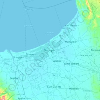
Name: Dagupan topographic map, elevation, terrain.
Location: Dagupan, Pangasinan, Ilocos Region, Philippines (15.88302 120.17376 16.20302 120.49376)
Average elevation: 12 m
Minimum elevation: -1 m
Maximum elevation: 319 m
Make a donation
Other topographic maps
Click on a map to view its topography, its elevation and its terrain.
Make a donation
Urdaneta
Rainfall is heaviest in August, which is typically the peak of the rainy season, and lightest in January during the dry period. Humidity remains high year-round due to the city’s low elevation and proximity to coastal air masses, contributing to consistently warm and humid conditions.
Average elevation: 29 m
Make a donation
Make a donation
Urdaneta
Rainfall is heaviest in August, which is typically the peak of the rainy season, and lightest in January during the dry period. Humidity remains high year-round due to the city’s low elevation and proximity to coastal air masses, contributing to consistently warm and humid conditions.
Average elevation: 29 m
Make a donation
Urdaneta
Rainfall is heaviest in August, which is typically the peak of the rainy season, and lightest in January during the dry period. Humidity remains high year-round due to the city’s low elevation and proximity to coastal air masses, contributing to consistently warm and humid conditions. Humidity remains high…
Average elevation: 29 m
Make a donation
Make a donation
Make a donation
Agno River
The headwaters of Agno River are at the slopes of Mount Data in the Cordillera Mountains at an elevation of 2,090 metres (6,860 ft), where it drains Cretaceous to Paleocene igneous basement rocks, and marine siliciclastic and carbonate rocks. Of its total length, about 90 kilometres (56 mi) runs through…
Average elevation: 521 m
Make a donation
Make a donation
San Nicolas
During the latter part of the 18th century and the beginning of the 19th century, there was a significant migration of Ilocano families to Pangasinan, driven by factors such as rapid population growth and limited land availability for habitation and cultivation. While Ilocano migration to San Nicolas likely…
Average elevation: 397 m
Make a donation
Make a donation
Make a donation
Make a donation
Make a donation
Make a donation
Make a donation
Make a donation
Make a donation
Make a donation