
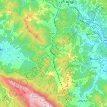
Legazpi topographic map
Interactive map
Click on the map to display elevation.
About this map
Name: Legazpi topographic map, elevation, terrain.
Average elevation: 548 m
Minimum elevation: 195 m
Maximum elevation: 1,411 m
Other topographic maps
Click on a map to view its topography, its elevation and its terrain.
Berastegi
Spain > Autonomous Community of the Basque Country
Berastegi, Gipuzkoa, Autonomous Community of the Basque Country, 20492, Spain
Average elevation: 502 m
Ayala/Aiara
Spain > Autonomous Community of the Basque Country > Aiarako kuadrilla/Cuadrilla de Ayala
Ayala/Aiara, Aiarako kuadrilla/Cuadrilla de Ayala, Álava, Autonomous Community of the Basque Country, Spain
Average elevation: 445 m
Araneta
Spain > Autonomous Community of the Basque Country > Gasteizko kuadrilla/Cuadrilla de Vitoria > Vitoria-Gasteiz > Bolívar
Araneta, Bolívar, Vitoria-Gasteiz, Gasteizko kuadrilla/Cuadrilla de Vitoria, Álava, Autonomous Community of the Basque Country, 01194, Spain
Average elevation: 625 m
Soil
Spain > Autonomous Community of the Basque Country > Montaña Alavesa/Arabako Mendialdea
Soil, Arraia-Maeztu, Montaña Alavesa/Arabako Mendialdea, Álava, Autonomous Community of the Basque Country, 01207, Spain
Average elevation: 898 m
Zumarraga
Spain > Autonomous Community of the Basque Country
Zumarraga, Gipuzkoa, Autonomous Community of the Basque Country, 20700, Spain
Average elevation: 500 m
Elvillar/Bilar
Spain > Autonomous Community of the Basque Country > Elvillar/Bilar
Elvillar/Bilar, Arabako Errioxa/Rioja Alavesa, Álava, Autonomous Community of the Basque Country, Spain
Average elevation: 561 m
Gipuzkoa
Spain > Autonomous Community of the Basque Country
Gipuzkoa, Autonomous Community of the Basque Country, Spain
Average elevation: 396 m
Okondo
Spain > Autonomous Community of the Basque Country > Okondo > Okondo
Okondo, Aiarako koadrilla/Cuadrilla de Ayala, Álava, Autonomous Community of the Basque Country, 01409, Spain
Average elevation: 323 m