Geolocate

Central Luzon topographic map

Click on the map to display elevation.

About this map

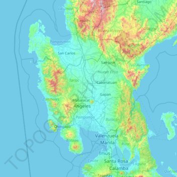
Name: Central Luzon topographic map, elevation, terrain.

Location: Central Luzon, Philippines (14.28530 119.64561 16.50237 122.38357)

Average elevation: 191 m

Minimum elevation: -1 m

Maximum elevation: 2,840 m

Other topographic maps

Click on a map to view its topography, its elevation and its terrain.

Tacloban

Philippines > Leyte > Tacloban

Average elevation: 29 m

Vigan

Philippines > Ilocos Sur

Vigan is situated in a Quaternary Age sedimentary plain called the Vigan-Bantay Plain which is part of the Ilocos coastal plain. The Vigan-Bantay Plain is bounded on the east by a moderately rugged Miocene sediments consisting of interbedded sandstones and shale to very rugged Meta-volcanics and Meta sediment…

Average elevation: 63 m

Bacolod

Philippines

Bacólod (English: Bacolod), is derived from bakólod (Old Spelling: bacólod), the Old Hiligaynon (Old Ilonggo) (Old Spelling: Ylongo and Ilongo) word for a "hill, turtle, mound, rise, hillock, down, any small eminence or elevation", since the resettlement was founded on a stony, hilly area, now the barangay…

Average elevation: 49 m

Quezon City

Philippines

Founded as a pueblo by Saint Pedro Bautista in 1590, San Francisco del Monte may be considered Quezon City's oldest district. The original land area of the old town of San Francisco del Monte was approximately2.5 square kilometres (1.0 sq mi) and covered parts of what is currently known as Project 7 and 8 and…

Average elevation: 57 m

Santa Rosa

Philippines > Laguna > Santa Rosa

Average elevation: 65 m

Iligan

Philippines

Average elevation: 229 m

Capangpangan

Philippines > Ilocos Sur > Vigan

Average elevation: 10 m

Paco Park

Philippines > Manila

Average elevation: 7 m

San Pablo

Philippines > Laguna > San Pablo

Average elevation: 220 m

Baganian

Philippines > Zamboanga del Sur > Tabina

Average elevation: 51 m

Cabalagnan

Philippines > Samar > Hinabangan

Average elevation: 353 m

Lamalama

Philippines > Cotabato > President Roxas

Average elevation: 145 m

Bacoor

Philippines > Cavite

Average elevation: 18 m

Lapu-Lapu

Philippines

Average elevation: 93 m

Baguio

Philippines

In 1903, Filipinos, Japanese and Chinese workers were hired to build Kennon Road, the first road directly connecting Baguio with the lowlands of La Union and Pangasinan. Before this, the only road to Benguet was Naguilian Road, and it was largely a horse trail at higher elevations. Camp John Hay was…

Average elevation: 881 m

San Sebastian

Philippines > Batangas > Mataasnakahoy

Average elevation: 160 m

Bolo Creek

Philippines > Benguet > La Trinidad > Cruz > Cabanao

Average elevation: 1,313 m

Malasag

Philippines > Cagayan de Oro

Average elevation: 211 m

Pinanggaan

Philippines > Nueva Ecija > Jaen

Average elevation: 21 m

Tanay

Philippines > Rizal

Average elevation: 32 m

Butuan

Philippines

Average elevation: 115 m

San Jose

Philippines > Northern Samar

The municipality is in a valley bounded on the east by the Palusong Mountain Range moving south and on the west by the Hitaasan Mountain Range. The land is generally alluvial flat and swamplands which has an elevation of less than 10 metres (33 ft) above sea level, while going south, south easterly, the…

Average elevation: 15 m

Oas

Philippines > Albay

Average elevation: 39 m

Timpas

Philippines > Capiz > Panitan

Average elevation: 75 m

Barangay 10

Philippines > Quezon > Catanauan

Average elevation: 13 m

Cambugahay Falls

Philippines > Siquijor > Lazi > Tagmanocan

Average elevation: 83 m

Limunsudan Falls

Philippines > Iligan

Average elevation: 690 m

Indulang

Philippines > Bukidnon > Talakag

Average elevation: 696 m

Portic

Philippines > Pangasinan > Bugallon

Average elevation: 16 m

Cambugahay Falls

Philippines > Siquijor > Lazi > Tagmanocan

Average elevation: 83 m

Bashoy

Philippines > Benguet

Average elevation: 1,446 m

Campisong

Philippines > Cebu > Ginatilan

Average elevation: 305 m

Raradangan

Philippines > Cotabato > Alamada

Average elevation: 234 m

Malagyan

Philippines > Iloilo > Miagao

Average elevation: 45 m

Jose Rizal

Philippines > Davao del Sur > Santa Cruz

Average elevation: 272 m

Malinao Dam

Philippines > Bohol > Del Pilar

Average elevation: 152 m

Bayang

Philippines > Lanao del Sur

The topography of the municipality is generally characterized by moderately sloping lands. Approximately 2,606 hectares (63.45%) have moderate slopes of 8 – 15%. Steep lands with a slope 40 – 60% comprise 20.14% (827) ha. About 674 (16.41) have nearly level terrain.

Average elevation: 782 m

Imelda

Philippines > Zamboanga del Norte > Gutalac

Average elevation: 103 m

Purok 2

Philippines > Bulacan > Bulakan > Santa Ines

Average elevation: 4 m

Montalban

Philippines > Rizal > Rodriguez

Rodriguez is generally very rough in topography, with 83% of its total land area composed of upland areas, hills and mountain ranges. The remaining 17% low-lying terrain and rolling lands are found at the south-western portion of the municipality, along with the northern portions of the Municipality of San…

Average elevation: 99 m

Tagum

Philippines > Davao del Norte

One of the significant accomplishments of the officialdom of Tagum during the 1990s was its elevation from a second to the first-class municipality. This opened a gateway to increase its financial resources through the Internal Revenue Allocation (IRA) from the national government and local revenues. This was…

Average elevation: 103 m

Cebu City

Philippines > Cebu > Cebu City

Average elevation: 140 m

Kaliwa Dam

Philippines > Cavite > General Trias

Average elevation: 22 m

Pantabangan Dam

Philippines > Nueva Ecija > Pantabangan > Fatima

The dam is a 107 m (351 ft) tall and 1,615 m (5,299 ft) long embankment-type with 12,000,000 cu yd (9,174,658 m3) of homogeneous earth-fill and an impervious core. The crest of the dam is 12 m (39 ft) wide while the widest part of its base is 535 m (1,755 ft). The dam's crest sits at an elevation of 232 m (761…

Average elevation: 210 m

Magat Dam

Philippines > Isabela

Average elevation: 175 m

Angat Dam

Philippines > Bulacan > Norzagaray > San Lorenzo > Suha

Average elevation: 254 m

Talima

Philippines > Lapu-Lapu

Average elevation: 3 m

Limunsudan

Philippines > Iligan

Average elevation: 781 m

Limunsudan Falls

Philippines > Iligan

Average elevation: 690 m

Linangkayan

Philippines > Misamis Oriental > Naawan

Average elevation: 15 m

Manganip

Philippines > Abra > Danglas

Average elevation: 102 m

Calbayog

Philippines > Samar > Calbayog

Forty percent of the city's land area are plain and hilly terrains with elevation ranging from 5 to 20 metres (16 to 66 ft) above sea level. The rest are rugged mountain ranges with elevations from 300 to 700 metres (980 to 2,300 ft) above sea level. Flooding is minimized because of many rivers, brooks,…

Average elevation: 55 m

Sala

Philippines > Quezon > Tiaong > Lumingon

Average elevation: 53 m

Betes

Philippines > Nueva Ecija > Aliaga

Average elevation: 30 m

Usab

Philippines > Masbate > Masbate City

Average elevation: 42 m

Samal Island

Philippines > Davao del Norte > Samal

Average elevation: 117 m

Caloocan

Philippines > Caloocan > Caloocan

Average elevation: 19 m

Malolos

Philippines > Bulacan

Malolos is relatively flat of about 0.81% to a gently sloping of 2.17%. The slope of the land descends towards west, southwest to southern direction. The highest land elevation is at about 6.0 meters above sea level while the lowest is only half a meter below sea level. A network of natural waterways and…

Average elevation: 6 m

Zamboanga City

Philippines > Zamboanga Peninsula > Zamboanga City

The overall topography of the city could be described as rolling to very steep. There are some flat lands, mostly narrow strips along the east coast. The urban center is mostly flat with a gentle slope to the interior, ranging from 0 to 3%. The highest registered elevation is 1,200 metres. In terms of slope, a…

Average elevation: 83 m

Santo Cristo

Philippines > Nueva Ecija > San Antonio

Average elevation: 15 m

San Rafael

Philippines > Antique > Patnongon

Average elevation: 57 m

Cabicungan River

Philippines > Cagayan > Claveria > San Antonio

Average elevation: 18 m

Palta Salvacion

Philippines > Catanduanes > Virac

Average elevation: 70 m

Santa Cruz

Philippines > Sorsogon > Donsol

Average elevation: 41 m

Pocto

Philippines > Surigao del Sur > Hinatuan

Average elevation: 60 m

Binurong Point

Philippines > Catanduanes > Baras > Guinsaanan

Average elevation: 12 m

Mandaue

Philippines

It is one of the two (the other one being the municipality of Consolacion) local government units located within the mainland Metro Cebu where the elevation of land is less than 100 m (330 ft).

Average elevation: 109 m

Amadeo

Philippines > Cavite > Amadeo

Average elevation: 422 m

Tagaytay

Philippines > Cavite

The southern and eastern portions of Tagaytay are covered by hills and mountains which is generally forests, pine trees and open grasslands. The city lies along Tagaytay Ridge, a ridge stretching about 32 kilometres (20 mi) from Mount Batulao in the west to Mount Sungay in the east with elevations averaging…

Average elevation: 229 m

Pasay

Philippines

Average elevation: 14 m

Sorsogon City

Philippines > Sorsogon

Sorsogon City covers a land area of 31,292 hectares (120.82 sq mi). It is at the southernmost tip of the Bicol Peninsula and of Luzon Island. The city is bounded by Castilla in the west, Manito in the northwest, Albay Gulf in the north, Prieto Diaz in the east, Gubat in the southeast, Casiguran in the…

Average elevation: 89 m

Mabinit

Philippines > Albay > Legazpi

Average elevation: 112 m

Palta Salvacion

Philippines > Catanduanes > Virac

Average elevation: 70 m

Andap

Philippines > Davao de Oro > New Bataan

Average elevation: 491 m

Cantaan

Philippines > Camiguin > Guinsiliban

Average elevation: 51 m

Esmeralda

Philippines > Pangasinan > Balungao

Average elevation: 60 m

Burgos

Philippines > Negros Occidental > Pontevedra

Average elevation: 133 m

Looc

Philippines > Camiguin > Catarman

Average elevation: 53 m

Behia

Philippines > Sorsogon > Magallanes

Average elevation: 8 m

San Teodoro

Philippines > Agusan del Sur > Bunawan

Average elevation: 48 m

Alfonso

Philippines > Cavite > Alfonso

Average elevation: 413 m

San Fernando

Philippines > La Union

Average elevation: 81 m

Daraga

Philippines > Albay

67.3% of the total municipal land area has a predominantly low elevation of up to 100 metres (330 ft). The surface terrain is generally characterized by combination of level to nearly level areas, gentle to undulating areas and undulating to rolling areas.

Average elevation: 76 m

San Juan

Philippines

"San Juan" is a contraction of the city's traditional name of "San Juan del Monte" (lit. 'Saint John of the Mountain'). As with numerous other places in the Philippines, the name combines a patron saint and a toponym; in this case Saint John the Baptist with the locale's hilly terrain and relatively higher…

Average elevation: 35 m

Magais II

Philippines > Del Gallego

Average elevation: 43 m

Sogod-Tibgao

Philippines > Catanduanes > Virac

Average elevation: 87 m

Capisan

Philippines > Zamboanga City

Average elevation: 348 m

Aw-asen Falls

Philippines > Ilocos Sur

Average elevation: 467 m

Panlaitan

Philippines > Palawan > Busuanga

Average elevation: 5 m

Tabug

Philippines > Ilocos Norte

Average elevation: 26 m

Calauag Bay

Philippines > Quezon > Calauag

Average elevation: 0 m

Tabina

Philippines > Zamboanga del Sur

Average elevation: 53 m

Tukod

Philippines > Bulacan > San Rafael

Average elevation: 79 m

Ormoc

Philippines > Leyte > Ormoc

Average elevation: 204 m

Antipolo

Philippines > Rizal

Its higher elevation than that of Metro Manila affords it a scenic view of the metropolis, especially at night. Its locally grown mangoes and cashews are popular among tourists, as well as suman – a local delicacy made out of glutinous rice. The Hinulugang Taktak National Park, which was once a popular…

Average elevation: 125 m

Anonang

Philippines > Zamboanga del Sur > Aurora

Average elevation: 122 m

Paranas

Philippines > Samar

Average elevation: 42 m

Tagoloan

Philippines > Lanao del Norte

Average elevation: 468 m

Cajumpan

Philippines > Samar > Calbayog

Average elevation: 9 m