
Tarlac City topographic map
Interactive map
Click on the map to display elevation.
About this map
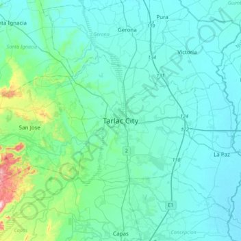
Name: Tarlac City topographic map, elevation, terrain.
Location: Tarlac City, Tarlac, Central Luzon, Philippines (15.32612 120.42935 15.64612 120.74935)
Average elevation: 56 m
Minimum elevation: 13 m
Maximum elevation: 376 m
Other topographic maps
Click on a map to view its topography, its elevation and its terrain.
Pura
Pura, just like any other town in the province of the Tarlac has two (2) pronounced seasons. The wet season that starts from May up to lasts up to September and dry from the month of October to April. This type of climate is typically hot, humid, and tropical and is generally affected by the neighboring…
Average elevation: 23 m
Camiling
Mostly of plain topography but some parts are hilly to mountainous in which the barangays of Papaac, Bacsay, Birbira and Cayasan, to name a few. The deeper part of the mountains can be described as a place where wild animals live, such as deer, Toddy cat (Musang), wild boar (Baboy ramo), Monitor lizard…
Average elevation: 32 m