
Namibia topographic map
Interactive map
Click on the map to display elevation.
About this map
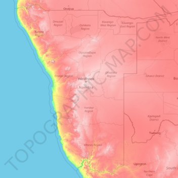
Name: Namibia topographic map, elevation, terrain.
Location: Namibia (-28.96945 11.52804 -16.96351 25.26173)
Average elevation: 783 m
Minimum elevation: 0 m
Maximum elevation: 2,328 m
The Central Plateau runs from north to south, bordered by the Skeleton Coast to the northwest, the Namib Desert and its coastal plains to the southwest, the Orange River to the south, and the Kalahari Desert to the east. The Central Plateau is home to the highest point in Namibia at Königstein elevation 2,606 metres (8,550 ft).
Other topographic maps
Click on a map to view its topography, its elevation and its terrain.
Philippines
Philippines
Average elevation: 33 m
Suffolk County
Suffolk County, New York, United States
Average elevation: 34 m
Marikina
Philippines > Marikina > Marikina
Marikina, Eastern Manila District, Metro Manila, Philippines
Average elevation: 30 m
Cebu City
Philippines > Cebu > Cebu City
Cebu City, Cebu, Central Visayas, 6000, Philippines
Average elevation: 140 m
Sandy
United States > Oregon > Clackamas County
Sandy, Clackamas County, Oregon, 97055, United States
Average elevation: 247 m
Batangas City
Batangas City, Batangas, Calabarzon, 4200, Philippines
Average elevation: 65 m
Quezon City
Quezon City, Eastern Manila District, Metro Manila, Philippines
Average elevation: 57 m
Mount Balatukan
Philippines > Misamis Oriental
Mount Balatukan, Misamis Oriental, Northern Mindanao, Philippines
Average elevation: 1,927 m
Huddersfield
United Kingdom > England > Kirklees
Huddersfield, Kirklees, West Yorkshire, England, HD1 2AA, United Kingdom
Average elevation: 145 m
Baguio
Baguio, Cordillera Administrative Region, 2600, Philippines
Average elevation: 1,371 m
Marikina River
Marikina River, Malanday, Marikina, Second District, Metro Manila, 1805, Philippines
Average elevation: 66 m
Boise
United States of America > Idaho > Boise
Boise, Ada County, Idaho, 83702, United States of America
Average elevation: 1,040 m
Dasmarinas
Philippines > Cavite > Dasmarinas > Buhi
Dasmarinas, Cavite, Calabarzon, 4114, Philippines
Average elevation: 114 m
Tondo
Tondo, First District, Manila, Capital District, Metro Manila, Philippines
Average elevation: 5 m
Sorsogon City
Sorsogon City, Sorsogon, Bicol Region, 4700, Philippines
Average elevation: 89 m
Mandaluyong
Mandaluyong, Eastern Manila District, Metro Manila, 1551, Philippines
Average elevation: 33 m
Galicia III
Philippines > Cavite > Mendez
Galicia III, Mendez, Cavite, Calabarzon, 4121, Philippines
Average elevation: 557 m
Tacloban
Philippines > Leyte > Tacloban
Tacloban, Leyte, Eastern Visayas, 6500, Philippines
Average elevation: 29 m
Malolos
Malolos, Bulacan, Central Luzon, 3000, Philippines
Average elevation: 6 m
Zamboanga City
Philippines > Zamboanga Peninsula > Zamboanga City
Zamboanga City, Zamboanga Peninsula, 7000, Philippines
Average elevation: 83 m
Laguerta
Philippines > Laguna > Calamba
Laguerta, Calamba, Laguna, Calabarzon, 4027, Philippines
Average elevation: 193 m
Falls Township
United States > Pennsylvania > Bucks County
Falls Township, Bucks County, Pennsylvania, United States
Average elevation: 15 m
San Jose
Philippines > Bukidnon > Malaybalay
San Jose, Malaybalay, Bukidnon, Northern Mindanao, 8700, Philippines
Average elevation: 579 m
Kwamathukuza
South Africa > KwaZulu-Natal > Amajuba District Municipality > Newcastle Local Municipality
Kwamathukuza, Newcastle Local Municipality, Amajuba District Municipality, KwaZulu-Natal, 2951, South Africa
Average elevation: 1,199 m
Champ
France > Auvergne-Rhône-Alpes > Ardèche > Saint-Romain-de-Lerps > Roussiveyrent
Champ, Laye, Roussiveyrent, Saint-Romain-de-Lerps, Tournon-sur-Rhône, Ardèche, Auvergne-Rhône-Alpes, Metropolitan France, 07130, France
Average elevation: 501 m
Santa Ana
Philippines > Batangas > Calatagan
Santa Ana, Calatagan, Batangas, Calabarzon, 4215, Philippines
Average elevation: 21 m
Mayon
Philippines > Sorsogon > Castilla
Mayon, Castilla, Sorsogon, Bicol Region, 4713, Philippines
Average elevation: 57 m
Bradford County
Bradford County, Florida, United States
Average elevation: 45 m
Marine Base Beach
Philippines > Cavite > Ternate
Marine Base Beach, Ternate, Cavite, Calabarzon, 4111, Philippines
Average elevation: 35 m
Dalupiri
Philippines > Cagayan > Calayan
Dalupiri, Calayan, Cagayan, Cagayan Valley, Philippines
Average elevation: 203 m
UP Campus
UP Campus, Diliman, 4th District, Quezon City, Eastern Manila District, Metro Manila, 1101, Philippines
Average elevation: 59 m