
Mauritania topographic map
Interactive map
Click on the map to display elevation.
About this map
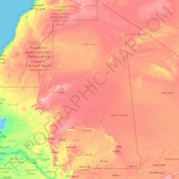
Name: Mauritania topographic map, elevation, terrain.
Location: Mauritania (14.72099 -17.23810 27.31494 -4.83333)
Average elevation: 262 m
Minimum elevation: -3 m
Maximum elevation: 912 m
A series of scarps face southwest, longitudinally bisecting these plains in the center of the country. The scarps also separate a series of sandstone plateaus, the highest of which is the Adrar Plateau, reaching an elevation of 500 metres or 1,600 feet. Spring-fed oases lie at the foot of some of the scarps. Isolated peaks, often rich in minerals, rise above the plateaus; the smaller peaks are called guelbs and the larger ones kedias. The concentric Guelb er Richat is a prominent feature of the north-central region. Kediet ej Jill, near the city of Zouîrât, has an elevation of 915 metres (3,000 ft) and is the highest peak. The plateaus gradually descend toward the northeast to the barren El Djouf, or "Empty Quarter," a vast region of large sand dunes that merges into the Sahara Desert. To the west, between the ocean and the plateaus, are alternating areas of clayey plains (regs) and sand dunes (ergs), some of which shift from place to place, gradually moved by high winds. The dunes generally increase in size and mobility toward the north.
Other topographic maps
Click on a map to view its topography, its elevation and its terrain.
Philippines
Philippines
Average elevation: 33 m
Cebu City
Philippines > Cebu > Cebu City
Cebu City, Cebu, Central Visayas, 6000, Philippines
Average elevation: 140 m
Boise
United States of America > Idaho > Boise
Boise, Ada County, Idaho, 83702, United States of America
Average elevation: 1,040 m
Dasmarinas
Philippines > Cavite > Dasmarinas > Buhi
Dasmarinas, Cavite, Calabarzon, 4114, Philippines
Average elevation: 114 m
Samal Island
Philippines > Davao del Norte > Samal
Samal Island, Samal, Island Garden City of Samal, Davao del Norte, Davao Region, 8119, Philippines
Average elevation: 117 m
Suffolk County
Suffolk County, New York, United States
Average elevation: 34 m
Marine Base Beach
Philippines > Cavite > Ternate
Marine Base Beach, Ternate, Cavite, Calabarzon, 4111, Philippines
Average elevation: 35 m
Laguerta
Philippines > Laguna > Calamba
Laguerta, Calamba, Laguna, Calabarzon, 4027, Philippines
Average elevation: 193 m
San Jose
Philippines > Bukidnon > Malaybalay
San Jose, Malaybalay, Bukidnon, Northern Mindanao, 8700, Philippines
Average elevation: 579 m
Anyatam
Philippines > Bulacan > San Ildefonso
Anyatam, San Ildefonso, Bulacan, Central Luzon, 3010, Philippines
Average elevation: 14 m
San Fernando
San Fernando, Pampanga, Central Luzon, 2000, Philippines
Average elevation: 24 m
Mayon
Philippines > Sorsogon > Castilla
Mayon, Castilla, Sorsogon, Bicol Region, 4713, Philippines
Average elevation: 57 m
Marikabayan Hill
Philippines > Cavite > Maragondon
Marikabayan Hill, Maragondon, Cavite, Calabarzon, 4112, Philippines
Average elevation: 72 m
Fort San Pedro
Fort San Pedro, Cebu South Coastal Road, San Roque, Cebu City, Central Visayas, 6000, Philippines
Average elevation: 3 m
Malabon
Philippines > Malabon > Malabon
Malabon, Northern Manila District, Metro Manila, 1479, Philippines
Average elevation: 17 m
Quezon City
Quezon City, Eastern Manila District, Metro Manila, Philippines
Average elevation: 57 m
Bradford County
Bradford County, Florida, United States
Average elevation: 45 m
Dalupiri
Philippines > Cagayan > Calayan
Dalupiri, Calayan, Cagayan, Cagayan Valley, Philippines
Average elevation: 203 m
Woombye
Australia > Queensland > Sunshine Coast Regional
Woombye, Sunshine Coast Regional, Queensland, 4559, Australia
Average elevation: 32 m
Mount Awapanniki
Philippines > Nueva Vizcaya > Kayapa
Mount Awapanniki, Kayapa, Nueva Vizcaya, Cagayan Valley, Philippines
Average elevation: 1,640 m
Batangas City
Batangas City, Batangas, Calabarzon, 4200, Philippines
Average elevation: 65 m
Santa Rosa
Philippines > Laguna > Santa Rosa
Santa Rosa, Laguna, Calabarzon, 4026, Philippines
Average elevation: 65 m
Malolos
Malolos, Bulacan, Central Luzon, 3000, Philippines
Average elevation: 6 m
Davao City
Philippines > Davao Occidental > Davao City
Davao City, Davao Region, Philippines
Average elevation: 303 m
Santa Ana
Philippines > Batangas > Calatagan
Santa Ana, Calatagan, Batangas, Calabarzon, 4215, Philippines
Average elevation: 21 m
Iraya (Del Rosario)
Iraya (Del Rosario), Camarines Sur, Bicol Region, 4433, Philippines
Average elevation: 157 m
San Francisco del Monte
San Francisco del Monte, 1st District, Quezon City, Eastern Manila District, Metro Manila, 1100, Philippines
Average elevation: 21 m
Baguio
Baguio, Cordillera Administrative Region, 2600, Philippines
Average elevation: 1,371 m
Marang River
Malaysia > Terengganu > Kampung Pengkalan Kuin
Marang River, Kampung Pengkalan Kuin, Marang, Terengganu, Malaysia
Average elevation: 23 m
Mandaluyong
Mandaluyong, Eastern Manila District, Metro Manila, 1551, Philippines
Average elevation: 33 m