
Itbayat topographic map
Interactive map
Click on the map to display elevation.
About this map
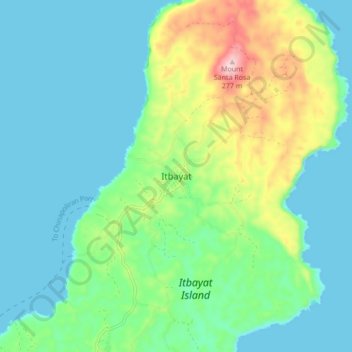
Name: Itbayat topographic map, elevation, terrain.
Location: Itbayat, Batanes, Cagayan Valley, 3905, Philippines (20.74781 121.80147 20.82781 121.88147)
Average elevation: 66 m
Minimum elevation: 0 m
Maximum elevation: 272 m
Other topographic maps
Click on a map to view its topography, its elevation and its terrain.
Itbayat Island
Philippines > Batanes > Itbayat
Itbayat Island, Itbayat, Batanes, Cagayan Valley, 3905, Philippines
Average elevation: 31 m
Mount Riposet
Philippines > Batanes > Itbayat
Mount Riposet, Mayan-Raele Road, Itbayat, Batanes, Cagayan Valley, 3905, Philippines
Average elevation: 69 m