
Juban topographic map
Interactive map
Click on the map to display elevation.
About this map
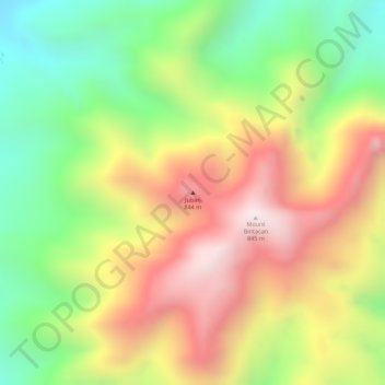
Name: Juban topographic map, elevation, terrain.
Location: Juban, Sorsogon City, Sorsogon, Bicol Region, Philippines (12.79755 123.93379 12.79765 123.93389)
Average elevation: 465 m
Minimum elevation: 120 m
Maximum elevation: 804 m
Other topographic maps
Click on a map to view its topography, its elevation and its terrain.
Irosin Caldera
Philippines > Sorsogon > Sorsogon City
Irosin Caldera, Sorsogon City, Sorsogon, Bicol Region, 4704, Philippines
Average elevation: 147 m
Malaumauan Island
Philippines > Sorsogon > Sorsogon City
Malaumauan Island, Sorsogon City, Sorsogon, Bicol Region, Philippines
Average elevation: 0 m
Juac Island
Philippines > Sorsogon > Sorsogon City
Juac Island, Sorsogon City, Sorsogon, Bicol Region, Philippines
Average elevation: 1 m
Gate Mountains
Philippines > Sorsogon > Sorsogon City
Gate Mountains, Sorsogon City, Sorsogon, Bicol Region, Philippines
Average elevation: 156 m
Bagatao Island
Philippines > Sorsogon > Sorsogon City
Bagatao Island, Sorsogon City, Sorsogon, Bicol Region, Philippines
Average elevation: 9 m
Sablayan Island
Philippines > Sorsogon > Sorsogon City
Sablayan Island, Sorsogon City, Sorsogon, Bicol Region, Philippines
Average elevation: 13 m