
Puerto Galera topographic map
Interactive map
Click on the map to display elevation.
About this map
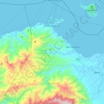
Name: Puerto Galera topographic map, elevation, terrain.
Location: Puerto Galera, Oriental Mindoro, Mimaropa, 5221, Philippines (13.26026 120.80067 13.58084 121.03968)
Average elevation: 442 m
Minimum elevation: 0 m
Maximum elevation: 2,545 m
Other topographic maps
Click on a map to view its topography, its elevation and its terrain.
Baco
Philippines > Oriental Mindoro
Majority of the barangays of the municipality are in lowland areas or below 500 meters above sea level (MASL) and cover 41.88 percent of the total land area (13,035.58 ha). The three largest barangays, which cover most of the forestland, have an elevation that ranges from 500-1,000 and greater than 1,000…
Average elevation: 14 m
Mount Halcon
Philippines > Oriental Mindoro
Mount Halcon (Filipino: Bundok Halcon) and (Spanish: Monte Halcón) is the highest mountain in Mindoro. According to the new data released by Oriental Mindoro peakvisor as of 2022, it has an elevation of 2,616 metres (8,583 ft) above sea level, higher than the previous estimates of 2,586 m (8,484 ft) although…
Average elevation: 2,121 m
Calapan
Philippines > Oriental Mindoro
The overall land characteristic is a wide plain with rivers, interspersed with wetlands at the seacoast periphery. The highest elevation is 187 m (614 ft) above sea level at Bulusan Hill, a 6-kilometre (3.7 mi) long landform east of the city, which interrupts the mostly flat terrain north-east of the…
Average elevation: 40 m
Baco
Philippines > Oriental Mindoro
Majority of the barangays of the municipality are in lowland areas or below 500 meters above sea level (MASL) and cover 41.88 percent of the total land area (13,035.58 ha). The three largest barangays, which cover most of the forestland, have an elevation that ranges from 500-1,000 and greater than 1,000…
Average elevation: 14 m