
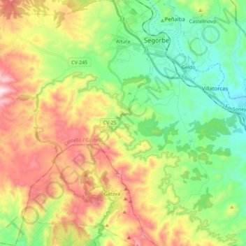
Altura topographic map
Interactive map
Click on the map to display elevation.
About this map
Name: Altura topographic map, elevation, terrain.
Average elevation: 524 m
Minimum elevation: 244 m
Maximum elevation: 971 m
Other topographic maps
Click on a map to view its topography, its elevation and its terrain.
Teresa
Spain > Valencian Community > Castelló / Castellón
Teresa, l'Alt Palància, Castelló / Castellón, Valencian Community, Spain
Average elevation: 752 m
Novaliches
Spain > Valencian Community > Castelló / Castellón > Jérica > Novaliches
Novaliches, Jérica, l'Alt Palància, Castelló / Castellón, Valencian Community, 12450, Spain
Average elevation: 488 m