
Quito topographic map
Interactive map
Click on the map to display elevation.
About this map
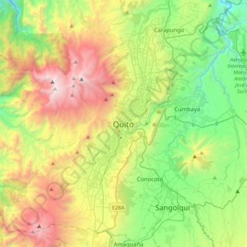
Name: Quito topographic map, elevation, terrain.
Location: Quito, Quito Canton, Pichincha, 170130, Ecuador (-0.38016 -78.67233 -0.06016 -78.35233)
Average elevation: 2,930 m
Minimum elevation: 1,897 m
Maximum elevation: 4,737 m
Quito (Spanish pronunciation: [ˈkito] ; Quechua: Kitu), officially San Francisco de Quito, is the capital of Ecuador, with an estimated population of 2.8 million in its metropolitan area. It is also the capital of the province of Pichincha. Quito is located in a valley on the eastern slopes of Pichincha, an active stratovolcano in the Andes, at an elevation of 2,850 m (9,350 ft), making it the highest or the second highest capital city in the world.
Other topographic maps
Click on a map to view its topography, its elevation and its terrain.
Conocoto
Ecuador > Pichincha > Quito Canton
Conocoto, Quito Canton, Pichincha, Ecuador
Average elevation: 2,670 m