
Distrito Chitré topographic map
Interactive map
Click on the map to display elevation.
About this map
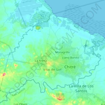
Name: Distrito Chitré topographic map, elevation, terrain.
Location: Distrito Chitré, Herrera, Panamá (7.93241 -80.51198 8.02779 -80.38675)
Average elevation: 16 m
Minimum elevation: 0 m
Maximum elevation: 126 m
Other topographic maps
Click on a map to view its topography, its elevation and its terrain.
Río La Villa
Panamá > Herrera > Distrito Chitré > Chitré
Río La Villa, Chitré, Distrito Chitré, Herrera, Panamá
Average elevation: 27 m