
Puerto Armuelles topographic map
Interactive map
Click on the map to display elevation.
About this map
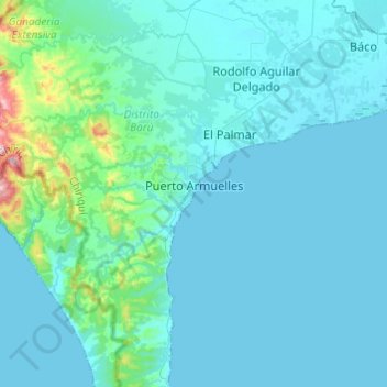
Name: Puerto Armuelles topographic map, elevation, terrain.
Location: Puerto Armuelles, Distrito Barú, Chiriquí, Panamá (8.16835 -83.05172 8.36721 -82.80906)
Average elevation: 46 m
Minimum elevation: 0 m
Maximum elevation: 526 m
Other topographic maps
Click on a map to view its topography, its elevation and its terrain.
Buena Vista (Spanish Town)
Panamá > Chiriquí > Distrito Barú > Puerto Armuelles > Monte Verde
Buena Vista (Spanish Town), Monte Verde, Puerto Armuelles, Distrito Barú, Chiriquí, 0406, Panamá
Average elevation: 21 m
Río Chiriquí Viejo
Panamá > Chiriquí > Distrito Barú > Progreso
Río Chiriquí Viejo, Progreso, Distrito Barú, Chiriquí, Panamá
Average elevation: 19 m
Charco Azul Bay
Panamá > Chiriquí > Distrito Barú > Rodolfo Aguilar Delgado
Charco Azul Bay, Rodolfo Aguilar Delgado, Distrito Barú, Chiriquí, Panamá
Average elevation: 29 m