
Yangudi Rassa National Park topographic map
Interactive map
Click on the map to display elevation.
About this map
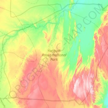
Name: Yangudi Rassa National Park topographic map, elevation, terrain.
Location: Yangudi Rassa National Park, 18, Zone 3, Afar, Éthiopie (10.67877 40.45691 11.23814 41.06262)
Average elevation: 622 m
Minimum elevation: 408 m
Maximum elevation: 967 m
Other topographic maps
Click on a map to view its topography, its elevation and its terrain.