
Tooele County topographic map
Interactive map
Click on the map to display elevation.
About this map
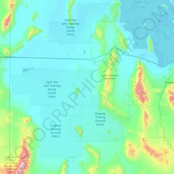
Name: Tooele County topographic map, elevation, terrain.
Location: Tooele County, Utah, United States of America (39.90384 -114.04838 41.07684 -112.14520)
Average elevation: 1,462 m
Minimum elevation: 1,279 m
Maximum elevation: 3,633 m
Tooele County lies on the west side of Utah. Its west border abuts the east border of the state of Nevada. Its northeast border abuts the Great Salt Lake. Three significant mountain ranges run north-south through the county. Its east boundary line is delineated by the crestline of the Oquirrh Mountains, which separate the Tooele Valley from the Salt Lake Valley. The Stansbury Mountains parallel the Oquirrhs in the eastern part of the county, and the Cedar Mountains also run parallel to the other two through the east-central part of the county. There are also isolated prominences across the county, especially at its SW corner. The county terrain is largely arid and unused for agriculture unless irrigation water is available. The county generally slopes to the north. Its highest elevation is Deseret Peak in the Stansburys, at 11,031' (3362m) ASL. The county has a total area of 7,286 square miles (18,870 km2), of which 6,941 square miles (17,980 km2) is land and 345 square miles (890 km2) (4.7%) is water.
Other topographic maps
Click on a map to view its topography, its elevation and its terrain.
Daggett County
United States of America > Utah
Daggett County, Utah, 84023, United States of America
Average elevation: 2,267 m
Sandy
United States of America > Utah > Sandy
Sandy, Salt Lake County, Utah, 84092, United States of America
Average elevation: 1,827 m
Salt Lake County
United States of America > Utah
Salt Lake County, Utah, United States of America
Average elevation: 1,811 m
Utah County
United States of America > Utah
Utah County, Utah, United States of America
Average elevation: 2,062 m
Duchesne County
United States of America > Utah
Duchesne County, Utah, United States of America
Average elevation: 2,408 m