
Volcán Cotopaxi topographic map
Interactive map
Click on the map to display elevation.
About this map
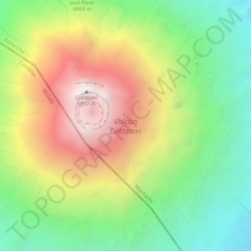
Name: Volcán Cotopaxi topographic map, elevation, terrain.
Location: Volcán Cotopaxi, Mulaló, Latacunga, Cotopaxi, Ecuador (-0.70639 -78.45393 -0.66584 -78.41413)
Average elevation: 5,021 m
Minimum elevation: 4,381 m
Maximum elevation: 5,869 m
Other topographic maps
Click on a map to view its topography, its elevation and its terrain.
Macaló Chico
Ecuador > Cotopaxi > Latacunga > Mulaló
Macaló Chico, Mulaló, Latacunga, Cotopaxi, Ecuador
Average elevation: 3,094 m