
Brooklyn topographic map
Interactive map
Click on the map to display elevation.
About this map
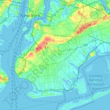
Name: Brooklyn topographic map, elevation, terrain.
Location: Brooklyn, Kings County, New York, United States of America (40.57002 -74.04197 40.73940 -73.85563)
Average elevation: 10 m
Minimum elevation: -10 m
Maximum elevation: 61 m
Other topographic maps
Click on a map to view its topography, its elevation and its terrain.
WCBS-AM (New York)
United States of America > New York > New York
WCBS-AM (New York), Terrace Street, City Island, New York, The Bronx, Bronx County, New York, 10464, United States of America
Average elevation: 1 m
Queens
United States of America > New York > New York
Queens, Queens County, New York, United States of America
Average elevation: 12 m
Bronx County
United States of America > New York > New York
Bronx County, New York, United States of America
Average elevation: 21 m