
Erbil Governorate topographic map
Interactive map
Click on the map to display elevation.
About this map
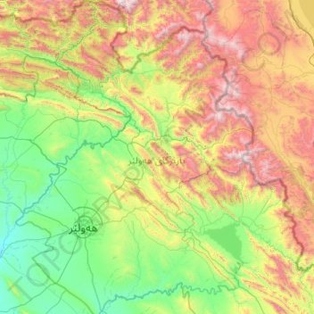
Name: Erbil Governorate topographic map, elevation, terrain.
Location: Erbil Governorate, Iraqi Kurdistan, Iraq (35.73286 43.58791 37.32299 45.07187)
Average elevation: 1,089 m
Minimum elevation: 204 m
Maximum elevation: 3,686 m
Other topographic maps
Click on a map to view its topography, its elevation and its terrain.
کەسنەزان
Iraq > Erbil Governorate > کەسنەزان
کەسنەزان, Kasnazan Subdistrict, Erbil Plains District, Erbil Governorate, Iraqi Kurdistan, 90010, Iraq
Average elevation: 604 m