
La Prade topographic map
Interactive map
Click on the map to display elevation.
About this map
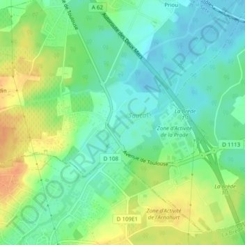
Name: La Prade topographic map, elevation, terrain.
Average elevation: 20 m
Minimum elevation: 4 m
Maximum elevation: 42 m
Other topographic maps
Click on a map to view its topography, its elevation and its terrain.
Priou
France > Nouvelle-Aquitaine > Saint-Médard-d'Eyrans > Priou
Priou, Saint-Médard-d'Eyrans, Bordeaux, Gironde, Nouvelle-Aquitaine, France métropolitaine, 33650, France
Average elevation: 13 m