Molbergen topographic map
Interactive map
Click on the map to display elevation.
About this map
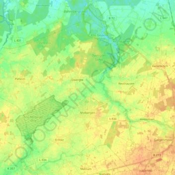
Name: Molbergen topographic map, elevation, terrain.
Location: Molbergen, Landkreis Cloppenburg, Nedersaksen, 49696, Duitsland (52.81683 7.79186 52.93660 7.99996)
Average elevation: 34 m
Minimum elevation: 17 m
Maximum elevation: 51 m
Other topographic maps
Click on a map to view its topography, its elevation and its terrain.
Barßel
Duitsland > Nedersaksen > Landkreis Cloppenburg
Barßel, Landkreis Cloppenburg, Nedersaksen, 26676, Duitsland
Average elevation: 4 m
Addrup
Duitsland > Nedersaksen > Landkreis Cloppenburg > Essen (Oldenburg)
Addrup, Dorfgemeinschaft Addrup, Essen (Oldenburg), Landkreis Cloppenburg, Nedersaksen, Duitsland
Average elevation: 28 m
Neuvrees
Duitsland > Nedersaksen > Landkreis Cloppenburg > Friesoythe
Neuvrees, Friesoythe, Landkreis Cloppenburg, Nedersaksen, 26169, Duitsland
Average elevation: 14 m
Lindern (Oldenburg)
Duitsland > Nedersaksen > Landkreis Cloppenburg > Lindern (Oldenburg)
Lindern (Oldenburg), Landkreis Cloppenburg, Nedersaksen, 49699, Duitsland
Average elevation: 33 m
Cloppenburg
Duitsland > Nedersaksen > Landkreis Cloppenburg
Cloppenburg, Landkreis Cloppenburg, Nedersaksen, 49661, Duitsland
Average elevation: 41 m