
Buea topographic map
Interactive map
Click on the map to display elevation.
About this map
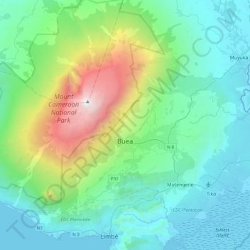
Name: Buea topographic map, elevation, terrain.
Location: Buea, Fako, Southwest, Cameroon (4.04421 9.02681 4.31928 9.41458)
Average elevation: 787 m
Minimum elevation: -6 m
Maximum elevation: 4,020 m
Buea has a subtropical highland climate. Because of its location at the foot of Mount Cameroon, the climate in Buea tends to be humid, with the neighbourhoods at higher elevations enjoying cooler temperatures while the lower neighbourhoods experience a hotter climate. Extended periods of rainfall, characterized by incessant drizzle, which can last for weeks, are common during the rainy season as are damp fogs, rolling off the mountain into the town below.
Other topographic maps
Click on a map to view its topography, its elevation and its terrain.