
Scotland topographic map
Interactive map
Click on the map to display elevation.
About this map
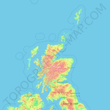
Name: Scotland topographic map, elevation, terrain.
Location: Scotland, United Kingdom (54.43398 -14.01552 61.06100 -0.32092)
Average elevation: 36 m
Minimum elevation: 0 m
Maximum elevation: 1,259 m
A significant exception to the above are the fossil-bearing beds of Old Red Sandstones found principally along the Moray Firth coast. The Highlands are generally mountainous and the highest elevations in the British Isles are found here. Scotland has over 790 islands divided into four main groups: Shetland, Orkney, and the Inner Hebrides and Outer Hebrides. There are numerous bodies of freshwater including Loch Lomond and Loch Ness. Some parts of the coastline consist of machair, a low-lying dune pasture land.
Other topographic maps
Click on a map to view its topography, its elevation and its terrain.
Kirkfell Tarn
United Kingdom > England > Cumberland
Kirkfell Tarn, Wasdale, Cumberland, England, United Kingdom
Average elevation: 460 m
Huddersfield
United Kingdom > England > Kirklees
Huddersfield, Kirklees, West Yorkshire, England, HD1 2AA, United Kingdom
Average elevation: 145 m
Royal Borough of Kensington and Chelsea
United Kingdom > England > London
Royal Borough of Kensington and Chelsea, London, Greater London, England, United Kingdom
Average elevation: 18 m
Courtlands
United Kingdom > England > Hertfordshire > Watford
Courtlands, Watford, Hertfordshire, England, WD24 5JT, United Kingdom
Average elevation: 85 m
Exmouth
United Kingdom > England > Devon > East Devon
Exmouth, East Devon, Devon, England, United Kingdom
Average elevation: 28 m
Waterbeach
United Kingdom > England > Cambridgeshire > South Cambridgeshire
Waterbeach, South Cambridgeshire, Cambridgeshire, Cambridgeshire and Peterborough, England, United Kingdom
Average elevation: 4 m
Gwyrch Castle Northern Towers
United Kingdom > Wales > Conwy > Llanddulas > Terfyn
Gwyrch Castle Northern Towers, A547, Terfyn, Llanddulas and Rhyd-y-Foel, Llanddulas, Conwy, Wales, LL22 8EY, United Kingdom
Average elevation: 54 m
Lynwilg
United Kingdom > Scotland > Highland > Aviemore
Lynwilg, Aviemore, Highland, Scotland, PH22 1PZ, United Kingdom
Average elevation: 294 m
Dava
United Kingdom > Scotland > Moray
Dava, Moray, Scotland, PH26 3PU, United Kingdom
Average elevation: 305 m
Belton
United Kingdom > England > Leicestershire > North West Leicestershire
Belton, North West Leicestershire, Leicestershire, England, United Kingdom
Average elevation: 90 m
London Borough of Newham
United Kingdom > England > London
London Borough of Newham, London, Greater London, England, United Kingdom
Average elevation: 8 m
Canterbury
United Kingdom > England > Kent
Canterbury, Kent, England, United Kingdom
Average elevation: 51 m
Leicester
United Kingdom > England > Leicestershire
Leicester, Leicestershire, England, LE1 5YA, United Kingdom
Average elevation: 109 m
Witchampton
United Kingdom > England > Dorset
Witchampton, Dorset, England, United Kingdom
Average elevation: 47 m
Nottingham Canal
United Kingdom > England > Nottinghamshire > Nottingham > Beeston
Nottingham Canal, Beeston, Nottingham, Nottinghamshire, England, United Kingdom
Average elevation: 33 m
Kinsham
United Kingdom > England > Worcestershire > Wychavon > Bredon
Kinsham, Bredon, Wychavon, Worcestershire, England, GL20 8GF, United Kingdom
Average elevation: 29 m
Glasgow
United Kingdom > Scotland > Glasgow City
Glasgow, Glasgow City, Scotland, G2 1DY, United Kingdom
Average elevation: 128 m
South Cambridgeshire
United Kingdom > England > Cambridgeshire
South Cambridgeshire, Cambridgeshire, Cambridgeshire and Peterborough, England, United Kingdom
Average elevation: 42 m
Bath
United Kingdom > England > Bath and North East Somerset
Bath, Bath and North East Somerset, West of England, England, United Kingdom
Average elevation: 100 m
Wimborne Minster
United Kingdom > England > Dorset
Wimborne Minster, Dorset, England, United Kingdom
Average elevation: 31 m
West Northamptonshire
West Northamptonshire, England, United Kingdom
Average elevation: 111 m
Thames Head
United Kingdom > England > Gloucestershire > Cotswold District > Kemble
Thames Head, Kemble, Cotswold District, Gloucestershire, England, GL7 6NZ, United Kingdom
Average elevation: 117 m
Temple Guiting
United Kingdom > England > Gloucestershire > Cotswold District
Temple Guiting, Cotswold District, Gloucestershire, England, GL54 5RP, United Kingdom
Average elevation: 241 m
Welton CP
United Kingdom > England > Lincolnshire > West Lindsey
Welton CP, West Lindsey, Lincolnshire, England, United Kingdom
Average elevation: 27 m
Ross-on-Wye
United Kingdom > England > Herefordshire
Ross-on-Wye, Herefordshire, England, United Kingdom
Average elevation: 61 m
Maidstone
United Kingdom > England > Kent
Maidstone, Kent, England, United Kingdom
Average elevation: 70 m
Mount
United Kingdom > England > Kirklees
Mount, Kirklees, West Yorkshire, England, HD3 3UQ, United Kingdom
Average elevation: 219 m
Biddenden
United Kingdom > England > Kent > Ashford
Biddenden, Ashford, Kent, England, United Kingdom
Average elevation: 46 m
Borough of Swale
United Kingdom > England > Kent
Borough of Swale, Kent, England, United Kingdom
Average elevation: 50 m
Read
United Kingdom > England > Lancashire > Ribble Valley
Read, Ribble Valley, Lancashire, England, United Kingdom
Average elevation: 114 m
Chippenham
United Kingdom > England > Wiltshire
Chippenham, Wiltshire, England, United Kingdom
Average elevation: 63 m
Charlwood
United Kingdom > England > Surrey > Mole Valley
Charlwood, Mole Valley, Surrey, England, United Kingdom
Average elevation: 72 m
Charnwood
United Kingdom > England > Leicestershire
Charnwood, Leicestershire, England, United Kingdom
Average elevation: 92 m
Yeovil
United Kingdom > England > Somerset
Yeovil, Somerset, England, United Kingdom
Average elevation: 63 m
Okehampton
United Kingdom > England > Devon > West Devon
Okehampton, West Devon, Devon, England, United Kingdom
Average elevation: 206 m
Wearne
United Kingdom > England > Somerset > Huish Episcopi
Wearne, Huish Episcopi, Somerset, England, TA10 9HB, United Kingdom
Average elevation: 32 m
Lyme Regis
United Kingdom > England > Dorset
Lyme Regis, Dorset, England, United Kingdom
Average elevation: 83 m
Taunton
United Kingdom > England > Somerset
Taunton, Somerset, England, TA1 1JD, United Kingdom
Average elevation: 39 m
Salisbury
United Kingdom > England > Wiltshire
Salisbury, Wiltshire, England, United Kingdom
Average elevation: 72 m
Carharrack
United Kingdom > England > Cornwall
Carharrack, Cornwall, England, United Kingdom
Average elevation: 119 m
Sherborne
United Kingdom > England > Dorset
Sherborne, Dorset, England, United Kingdom
Average elevation: 88 m
Swanage
United Kingdom > England > Dorset
Swanage, Dorset, England, United Kingdom
Average elevation: 38 m
Gillingham
United Kingdom > England > Dorset
Gillingham, Dorset, England, United Kingdom
Average elevation: 93 m
Trowbridge
United Kingdom > England > Wiltshire > Trowbridge
Trowbridge, Wiltshire, England, United Kingdom
Average elevation: 47 m
Chard
United Kingdom > England > Somerset
Chard, Somerset, England, TA20 2AX, United Kingdom
Average elevation: 135 m