
Make a donation
Saint-Gervais-les-Bains topographic map
Click on the map to display elevation.
Make a donation
Saint-Gervais-les-Bains
The main railway station for Saint-Gervais is the Gare de Saint-Gervais-les-Bains-Le Fayet. The Mont Blanc Tramway departs from the forecourt of Le Fayet station and reaches the Nid d'Aigle station at the Bionnassay glacier at an altitude of 2,372 m (7,782 ft). The Saint-Gervais–Vallorcine railway, a metre gauge line, departs from Le Fayet station and takes you to Chamonix and across the Swiss border to Martigny. Numerous other destinations throughout France (including direct trains to Paris) can be accessed from the main SNCF station in Le Fayet, and the main town centre is just a 10-minute descent to the nearby A40 Peage motorway to Geneva, Lyon, Paris and connecting to the rest of the French motorway network.
Make a donation
About this map
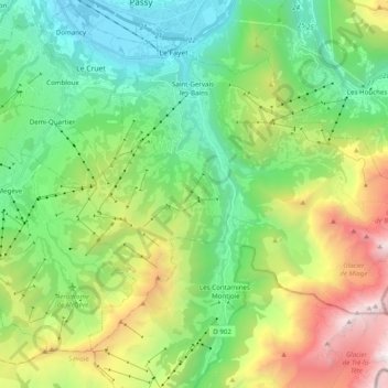
Name: Saint-Gervais-les-Bains topographic map, elevation, terrain.
Average elevation: 1,549 m
Minimum elevation: 547 m
Maximum elevation: 3,646 m
Make a donation
Other topographic maps
Click on a map to view its topography, its elevation and its terrain.
La Villa Trévi
France > Auvergne-Rhône-Alpes > Upper Savoy > Épagny Metz-Tessy
Average elevation: 493 m